Data shows winter was extreme
Editor’s note: This article is from the archives of the MSU Crop Advisory Team Alerts. Check the label of any pesticide referenced to ensure your use is included.
If it seemed like a long, cold winter, that's because it was (at least from a climatological perspective). A high amplitude jet stream pattern characterized by large troughs across western and central North America set up just before Thanksgiving last fall and persisted into early March. This pattern, typical of La Niña events in the equatorial Pacific (La Niña conditions have been in place since last fall,) led to a very active storm track through the Ohio Valley region and to the passage of a number of cold, arctic-origin air masses through the Great Lakes region. Mean temperatures for the December through February winter months generally ranged from two to five degrees Fahrenheit below normal across the state, and would have been even colder if not for milder than normal temperatures during February.
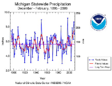
A time series graphic of mean winter temperatures for Michigan is given in Figure 1a (courtesy of NOAA). It is interesting to note that the relatively cold weather of this past winter and that of the last years' winter have at least temporarily ended a trend towards milder winter temperatures with mean values this year the coldest since the winter of 1993-1994. In terms of precipitation, winter totals generally ranged from near to slightly below normal levels across western sections of Upper Michigan to much above normal over large sections of the Lower Peninsula, where some areas received more than 200 percent of normal values. A time series plot of statewide winter precipitation (Figure 1b also courtesy of NOAA) suggests that this past winter was among the wettest 10 percent of winters since 1895, and that winter precipitation has generally trended upwards since the 1980's. Not surprisingly, with colder and wetter than normal weather during much of the winter, seasonal snowfall totals were heavier than normal across almost all areas of the state. Soil moisture levels currently range from much above normal levels across southern and central sections of the state to drier than normal across some northern sections. Subsoils are especially dry across western Upper Michigan where dryness has been a lingering problem for the past couple of years.
In the forecast, a large upper air trough is expected to move eastward from the western United States and into the Midwest by early next week. While some light snow will be possible across northern sections of Michigan through Saturday, most areas will remain dry through the upcoming weekend. The trough will ultimately bring the threat of rainfall to all of the state by Monday, March 23 continuing into Tuesday. Temperatures will moderate from highs ranging from the upper 30's north to the low 40's south Saturday to the mid- 40's north to low 50's south by Monday. Lows will warm from the 20's north to 30's south Saturday to the mid-upper 30's statewide by Monday.
Current medium range forecast guidance suggests more mid-continent troughing for the next week or so, with the possible formation of an upper air cut-off low feature, which would lead to a prolonged period of cold, cloudy, and unsettled weather, by late next week. The official NOAA 6-10 day outlook covering March 25-29 calls for mean temperatures to range from below normal levels in western sections of the state to above normal levels in the east. Precipitation totals are expected to increase to above normal levels statewide. For the 8-14 day period March 27 through April 2, the outlooks call for below normal mean temperatures and below normal precipitation totals statewide.
Long lead outlooks
There is not much new to report in the equatorial Pacific region with a general continuation of La Niña conditions. The official Climate Prediction Center long lead outlooks assume La Niña will continue through the spring months before dissipating into neutral conditions this summer. The new Climate Prediction Center outlooks put Michigan in the equal odds or climatology scenario for both mean temperatures and precipitation totals for April and for the April through June period. It is interesting to note that spring conditions during La Niña events in Michigan are typically wetter and cooler than normal, so in my mind this remains a possibility as well.
Latest medium range forecast guidance suggests a continuation of the upper air pattern mentioned above, with generally mild and fair weather broken by a few periods of precipitation and cold temperatures as troughing features occasionally break out of the western trough and move eastward across the country. Depending on how long this pattern lasts, some soils could dry sufficiently to allow some early fieldwork by late in the month.
Figure 1a . Mean winter temperatures (degrees F.) for Michigan, 1895-2009.
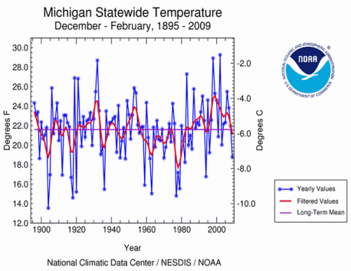
Figure 1b . Mean winter total precipitation (inches) across Michigan, 1895-2009.
Dr. Andresen's work is funded in part by MSU's AgBioResearch.


 Print
Print Email
Email