New watershed maps reflect Michigan’s updated legislative boundaries
 Print
Print Email
EmailResidents and elected officials can use this information to inform their actions regarding local water quality.
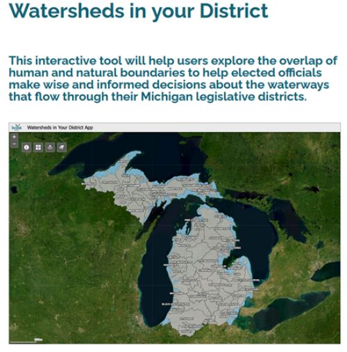
Have you ever wondered what watersheds fall in your state legislative districts? The boundaries of Michigan political districts often do not match natural watershed boundaries. A new interactive map from Michigan Sea Grant can help residents understand the relationship between Michigan’s state legislative district boundaries and its watersheds. The map is now available as part of the “Watersheds in Your District” webpage. The map has been updated to reflect the 2022 changes in Michigan’s State House and Senate districts.
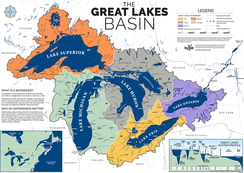
A watershed collects all the rain or snow from an area and drains it into a creek, river or lake. Physical features of the landscape such as hills and the elevation of the land create these natural boundaries that cause water to drain into a body of water. In Michigan, water in creeks and rivers eventually flows into one of the Great Lakes.
Many watersheds in the state have an associated watershed council or group that can be a source of information for both residents and state lawmakers. A list of these watershed groups can be found on the “Watersheds in Your District” webpage. These groups are also a great source of information on water quality issues for a particular watershed. Residents and elected officials can use this information to inform their actions regarding local water quality. Some issues that can impact water quality include flooding, combined sewer overflows and river or stream restoration projects. Local government policies can also impact water quality, as outlined in the three-part MSU Extension article series “Local government has an important role for water quality protection.” These collective efforts throughout the state can contribute to improvements in the health of the Great Lakes.
How to use the map
On the interactive map, residents can search by address to find their state House and Senate districts. There is also a watershed finder to select the State House or Senate District by number and view all of the watersheds that fall within that district. To generate a map to share, adjust the layers that are visible from the layer list on the right side panel and then take a screenshot that can later be printed or shared. There are additional instructions for use of the interactive map on the “Watersheds in Your District” webpage.
This new map is part of an effort by Michigan Sea Grant and the University of Michigan Water Center, in partnership with the Fred A. and Barbara M. Erb Family Foundation.
More resources available
For local and elected officials looking for additional ways to connect to local water resources, Michigan Water School is a fact-based program that explores topics like water quality, quantity, policy, economics, and more. Recordings of past webinars are available on the . Michigan Sea Grant is currently working with the Southeast Michigan Council of Governments (SEMCOG) and other partners to develop self-paced online courses about water infrastructure. Some of these modules will launch in Fall 2023 – subscribe to Upwellings or contact miwaters@msu.edu to learn more about these resources!
Michigan Sea Grant helps to foster economic growth and protect Michigan’s coastal, Great Lakes resources through education, research and outreach. A collaborative effort of the University of Michigan and Michigan State University and its MSU Extension, Michigan Sea Grant is part of the NOAA-National Sea Grant network of 34 university-based programs.
This article was prepared by Michigan Sea Grant under award NA22OAR4170084 from the National Oceanic and Atmospheric Administration, U.S. Department of Commerce through the Regents of the University of Michigan. The statement, findings, conclusions, and recommendations are those of the author(s) and do not necessarily reflect the views of the National Oceanic and Atmospheric Administration, the Department of Commerce, or the Regents of the University of Michigan.