


Southwest Michigan field crop update – Aug. 6, 2020
 Print
Print Email
EmailCooler temperatures and timely rain this past week have been a welcome site, but it may be triggering an increase in foliar disease, particularly in corn.
Weather
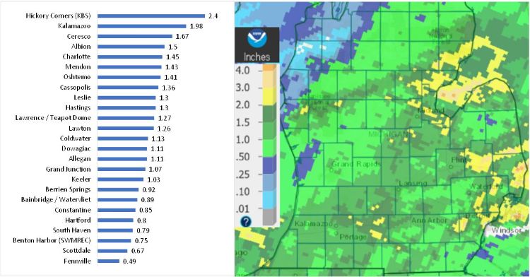
The southwest region received a bit of a reprieve this past week with lower temperatures and widespread rain showers. The Lower Peninsula received a much-needed dose of rain this past weekend, particularly in the drier parts of the Thumb and central region, while we received an average of 1.2 inches in our region. Our next good chance of rain will begin this coming Sunday, Aug. 9, with the highest chance on Monday, but the weather system moving through is expected to stall out over the Midwest bringing almost daily chances of rain next week.
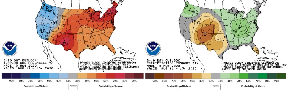
The 6-10 day outlook calls for a return to warmer-than-normal temperatures moving into the middle of August with a slight chance of higher-than-normal rainfall. The 8-14 day outlook also calls for higher than normal temperatures but below-normal precipitation; however, Michigan State University agricultural climatologist Jeff Andresen says he believes precipitation for the month will be close to normal.
Crops
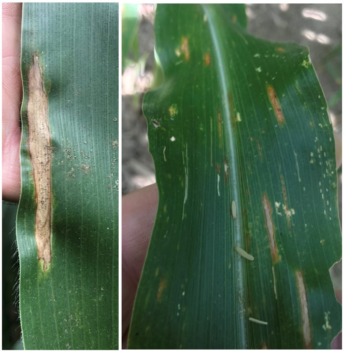
Corn looks very good moving into the grain fill stages, helped along by the widespread rainfall last weekend. Little insect feeding and foliar disease was seen in fields in St. Joseph County, although reports of tar spot lesions are increasing further west. Let us know if you see tar spot lesions beginning to appear in your fields. Be on the lookout for northern corn leaf blight and gray leaf spot as humid conditions persist in August in the lower canopy.
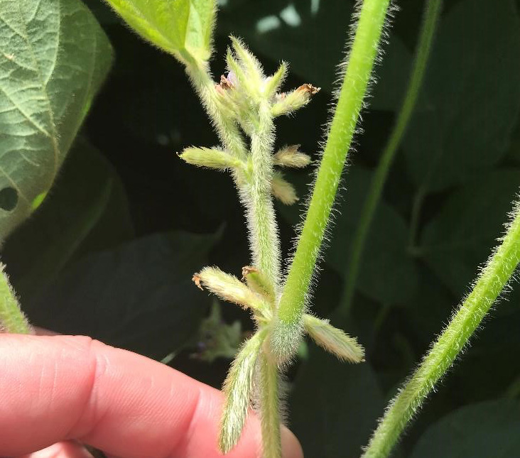
Early planted soybean fields have reached R4 with 0.75-inch pods at one of the four uppermost nodes. Though flowers can still be seen on plants, the highest risk of developing white mold, which attacks flowers, has passed. Another bright spot is that extended periods of moisture in the canopy (24-48 hours) tends to be just what is needed for fungal pathogens to crash spider mite populations.
Pests
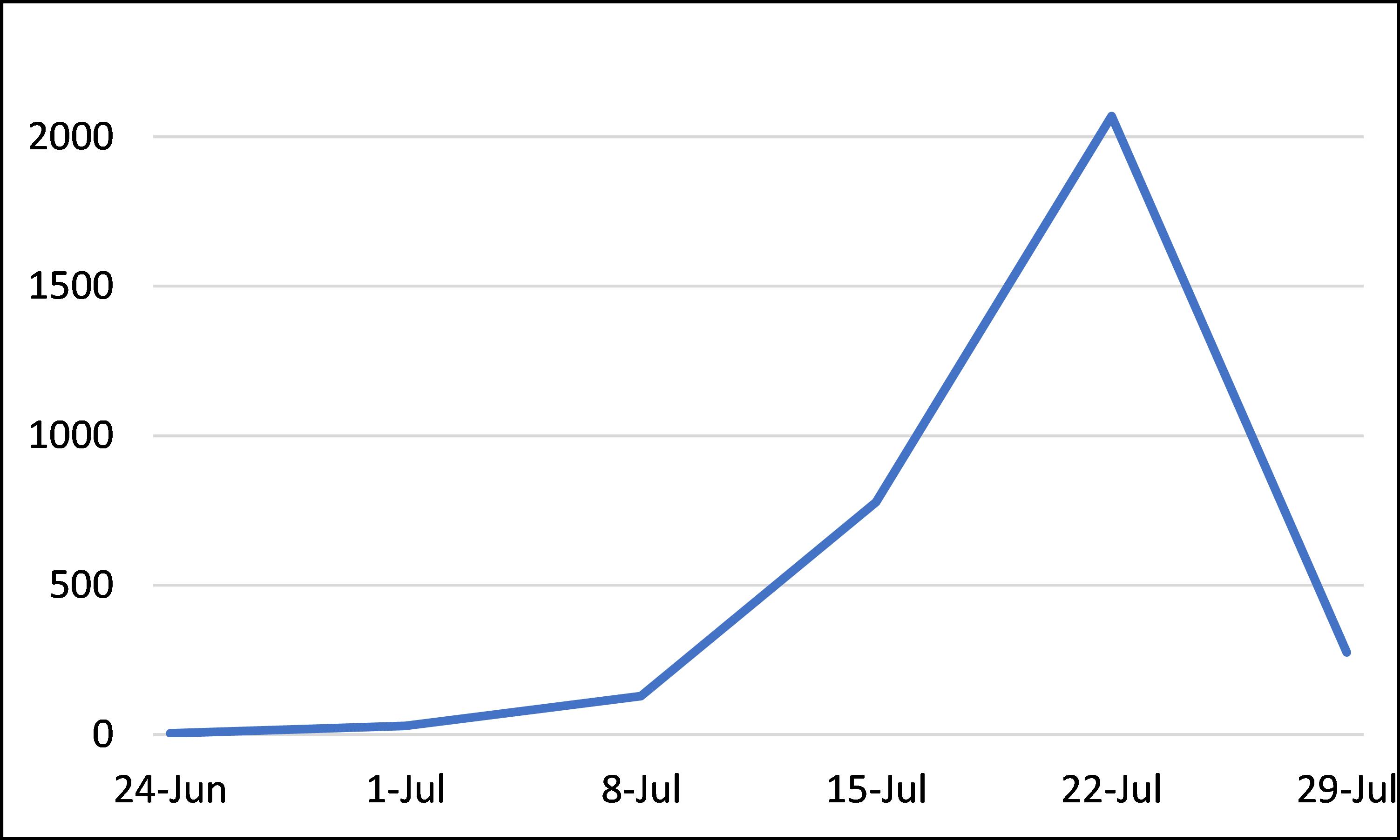
Western bean cutworm trap counts dropped off since the third week of July in Indiana and the southern Lower Peninsula. Reports from the northern Lower and Upper Peninsulas of hundreds of moths weekly are still coming in. Local traps (St. Joseph and Kalamazoo counties) had mostly single digit counts this past week. You can see moth capture data from several locations in Michigan on the Great Lakes and Maritimes Pest Monitoring Network. No ear borer signs have been seen yet.
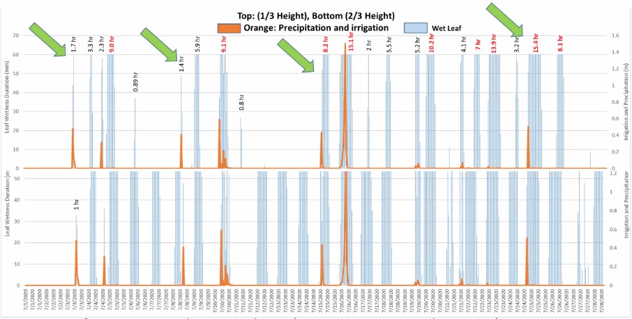
On the MSU Extension Field Crops Virtual Breakfast session this week, MSU Extension field crop pathologist Marty Chilvers and MSU/Purdue irrigation educator Lyndon Kelley addressed foliar diseases in corn and soybean with a focus on leaf wetness. Late July through early September is typically a time of high dew points in Michigan, meaning heavy dews are common this time of year. Extended rain events like last weekend and what may be coming next weekend increase the likelihood of increased disease severity with white mold in soybean (particularly in narrow rows) and tar spot in corn.
Irrigation that results in extended periods of leaf wetness increases the likelihood of disease progression. Chilvers says risk factors include lower air temperatures like we’ve seen this past week, average relative humidity higher than 75%, 10-20 foggy days per month, and, in particular, an average of 7 hours per night of leaf wetness.
If you were not able to join the Field Crops Virtual Breakfast, you can always view the recording on the MSU Extension Field Crops Team website. Podcasts are available on Spotify and Apple Podcast, and you can follow the team (@MSUEFieldCrops) on Twitter and Facebook.
MSU Extension field crop educator Bruce MacKellar has been doing extensive scouting for tar spot and working with Chilvers on research plots near Decatur, Michigan. He summarizes the main takeaways to be thinking about right now.
- Now is the time to scout. Prior to this week, early season tar spot has been confined mostly to lower leaves. This week, we began to see signs that a few fields in the Decatur/Paw Paw area have leaf lesions in the upper plant canopies (ear leaf and above). However, the majority of the fields checked (even under irrigation) have few to no leaf lesions right now. Now is the time to get out and check your fields to see what the tar spot situation is. Prioritize irrigated fields.
- The goal is to protect the upper canopy with fungicides if tar spot is found in your fields. The plants can tolerate some lower leaf damage, but the upper canopy is critical to provide photosynthate to the developing kernels.
- When to consider treating with fungicides. If you start finding lesions on a significant number of plants at the ear leaf level or above, consider treating with a fungicide. This is especially true if wet and cool weather is in the forecast.
- Largest concern going forward. Widespread aerial deposition of spores on upper plant canopy. Spores that come from the top are harder to scout and are more likely to affect a larger percentage of the plants in any given field.
- Highest risk weather. Prolonged periods of cool and wet weather. Temperatures in the 70s, cloudy and rainy would be the most likely to drive serious infections. We are getting into the time of year when morning fogs will extend the periods of leaf wetness, which occur every night when dews form. Hot and dry can reduce risk. Be aware that irrigation that extends leaf wetness can enhance the opportunity for infection of the leaves. Once widespread spore release starts, spread of the disease is likely to occur.
- Which fungicides are effective? The Corn Disease Working Group, made up of the pathologist from the land grant universities across the country, has put together a list of fungicides for control of various leaf diseases. You should download this resource.
- Will two fungicide sprays be necessary? Early planted corn I have walked is now at the R3 (milk) stage. The later planted corn began pollination about a week ago. The longer that fungicide applications can be safely delayed, the more likely it is that we can avoid having to make two applications to protect yields. Carefully evaluate the yield potential of the crop when making the decision to make a fungicide application, especially a second application.
