Could warm Great Lakes bring significant lake effect snow to Michigan?
 Print
Print Email
EmailWater temperature, wind direction and a chilly blast from Canada might push the snowfall totals.
As noted in Part 1 of this series, the fall 2016 water temperatures of the Great Lakes are significantly warmer than average and there is no ice that has even come close to forming as of late November, 2016. Meteorologist Mark Torregrossa’s research using two Lake Michigan NOAA buoys shows average surface water temperatures set a record high in Lake Michigan (consistent data has been collected from 1979 onward). This is due to a warm winter 2015-16 and a hot summer 2016. This is a stark contrast to three years ago when ice started forming in shallow protected areas of the Great Lakes by Thanksgiving, Nov.28, 2013. What are some of the implications this might portend?
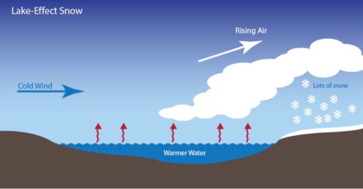
It is possible that very heavy lake effect snows could come from having such warm Great Lakes water. But it may not be that simple. Let’s start with a discussion of what lake effect snow actually is. Lake effect snow is created when a large temperature gradient exists between the surface of the Great Lakes and the temperature at 5000 feet above the ground. If the winds and temperatures are right, the air acts like a big sponge that sops up water from the lake and wrings it out on land in the form of snow. The direction of the wind is important—if the wind is blowing in a direction that covers more of the lake, the air will take in more water. The greater the temperature difference the more water the air will take in.
 There clearly is the warmth in the water. Perhaps a bigger question is will the cold air masses come in from Canada and for what duration to cause large lake effect? It seems a key to lake effect and annual snowfall amounts is likely related to the overall weather pattern which may have helped create the warm waters. In Traverse City where I reside, a new record high temperature was just reported by NOAA’s National Weather Service at 12:20 p.m. on Friday, Nov. 18, where the temperature was 71 degrees Fahrenheit. This is also the latest in the year that the temperature has been this warm since recordkeeping started in Traverse City in 1896.
We are also just getting started in a weak La Niña winter, contrasting with the strong El Niño winter of 2015-16. This may indicate a bit warmer than normal conditions from December to February. If this is the case, the winter may not be extremely wet or dry.
I have my snowblower ready for the lake effect snows that come to my region of Michigan. I’m sure we’ll have some good lake effect snows but I didn’t have to use the snowblower at all during November 2016. Time will tell how much Great Lakes water comes via lake effect this winter as well as the total amount of ice-cover for the season. I enjoy all four seasons so I look forward to enjoying the snow -- and hopefully some ice fishing (probably on inland lakes).
NOAA Great Lakes Environmental Research Lab has just announced that the water temperatures for all the Great Lakes are the warmest they have been since at least 2010 for the late November time frame. Data has been compiled from satellites and made into an animation (shown above) showing 2014/2016. Here is the full NOAA press release posted Nov. 28, 2016:
"According to data from NOAA Coastwatch's Great Lakes Environmental Research Laboratory, the temperatures of the Great Lakes are the warmest they've been since at least 2010 for this late in the month of November. Created with data from several satellites, this animation compares Great Lakes surface temperatures in 2014 with 2016. As you can see, the surface temperatures in November 2016 are several degrees warmer than those of this time two years ago.
As weather watchers -- and residents of the Great Lakes region -- know, the combination of warm lake waters and cold winter winds blowing across them is a perfect combination for lake effect snow, which NOAA defines as "snow showers that are created when cold, dry air passes over a large warmer lake, such as one of the Great Lakes, and picks up moisture and heat."
The last time that the Great Lakes were this warm was November 2010. That year, the lake surfaces remained mostly ice-free for the entire winter. Of course, just how much snow particular areas of the Great Lakes region will receive depends on which direction the winds blow. To see annual comparisons of various factors pertaining to the Great Lakes, visit the Great Lakes Environmental Research Laboratory's website. To see graphs depicting the average surface water temperatures of the Great Lakes for the past 5 years, click here. More information on satellite-derived measurements of sea (and lake) surface temperature is available here."
To keep up with snowfall amounts:
The Gaylord National Weather Service keeps a snowfall year to date graph with seasonal averages and departures available. All observation stations in this large geographic area are well below normal at this time except the Houghton Lake station. http://www.weather.gov/apx/snowgraph_ytd
To keep up with Great Lakes ice cover:
https://www.glerl.noaa.gov//data/ice/#currentConditions
Michigan Sea Grant helps to foster economic growth and protect Michigan’s coastal, Great Lakes resources through education, research and outreach. A collaborative effort of the University of Michigan and Michigan State University and its MSU Extension, Michigan Sea Grant is part of the NOAA-National Sea Grant network of 33 university-based programs.
Read this two-part series:
Part 1: How much ice should we expect to see on the Great Lakes this winter?
Part 2: Could warm Great Lakes bring significant lake effect snow to Michigan?