When it comes to aquatic invasive species, how do we know what we don't know?
 Print
Print Email
EmailGap analysis helps scientists understand what type of research is still needed to help them gain a more complete picture of invasive species' impact on Michigan.
With more than 180 aquatic nonnative species currently present in the Great Lakes and many more potential new invaders on the horizon, keeping track of what we know about these organisms is a challenge, and figuring out what we don’t know can be even more daunting.
One-stop information shop
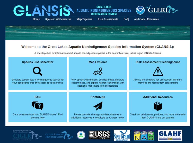
The Great Lakes Aquatic Nonindigenous Species Information System (GLANSIS) was designed to provide a one-stop shop for information on aquatic nonnative species, serving the needs of researchers, managers, educators, and other stakeholders in the Great Lakes region. GLANSIS currently contains more than 10,000 relevant bibliographic records and more than 90,0000 verified species reports along with structured analyses and profiles for each species. GLANSIS risk and organism impact assessments provide a framework for systematically gathering and organizing information across a broad array of taxa from viruses to wetland trees. As such, it is arguably the most comprehensive systematically curated collection of information on aquatic nonnative species available for the Great Lakes. However, as the old adage says: the more you learn, the more you realize you don’t know.
Finding the gaps
Even with so much information available, there are still gaps in the data that allow opportunities for further research. A gap analysis looks at what researchers want to know and compares it to the information currently available as a means of identifying where future work should concentrate. Michigan Sea Grant staff led a gap analysis for GLANSIS to identify both the state of database holdings (where GLANSIS staff should concentrate to address potential biases in data collection) as well as to assess gaps in the current state of science (where more research is needed to answer key questions about nonnative species).
To support early detection and efficient monitoring programs, we need to be able to predict which species are going to show up where. A key component of making such predictions is understanding the habitat requirements for each species and what critical factors limit their ability to survive, reproduce, and flourish. GLANSIS systematically scans the scientific literature to collate this type of information. The gap analysis demonstrates extensive deficits in the state of scientific knowledge for most species (Figure 1).
.jpg?language_id=1)
Perhaps the most fundamental question scientists ask is which of the 180+ established nonnative species are actually invasive – meaning they cause harm to the environment, economy, or human health. GLANSIS impact assessments are carefully designed to answer this question by systematically compiling data to answer 18 key questions addressing distinct categories of impact. For 30% of the nonnative species established in the Great Lakes, available scientific data is insufficient to provide an answer to this question, resulting in an assessment conclusion of ‘current research is inadequate to support proper assessment. The gap analysis demonstrates that microscopic species constitute 78% of the understudied and underreported species, that ecological impacts are more likely to lead to ‘unknown’ conclusions than socioeconomic impacts, and that understanding the impact of nonnative species to predator-prey relationships is a critical gap, with more than 100 of the established species lacking sufficient information to assess this key component of impact.
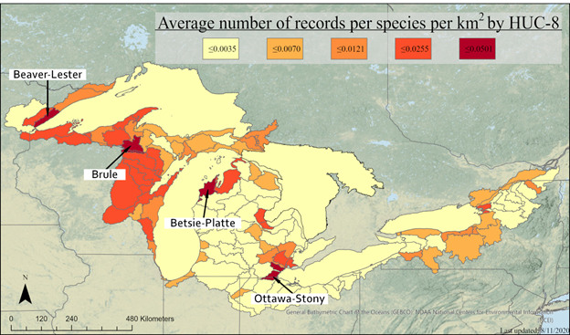
The gap analysis also took an in-depth look at geographic gaps by sub-watersheds. GLANSIS only records the presence of invasive species (not their absence), and therefore does not directly capture monitoring effort, but the number of reports per established species within a watershed should be reflective of the level of effort. The map shown indicates which watersheds have many reports for each established species (darker colors), and which have few reports (lighter colors) that entire species may have been missed. Community science
monitoring efforts, particularly when backed by expert verification of new finds, can play a key role in filling this type of information gap. GLANSIS partners with the USGS Nonindigenous Aquatic Species (NAS) database for verification of public reports. Sighting data reports can be contributed to GLANSIS online.
What are GLANSIS tech memos?
NOAA Technical Memoranda, otherwise known as tech memos, are used for the timely communication of raw data, preliminary results of scientific studies, or interim reports that may not have received formal external peer reviews in the style of academic journal articles or manuscripts. These numbered publications are publicly available online in PDF format and serve as important research documentation and reference material. For example this would be the listing for the gap analysis tech memo:
Sturtevant, R.A., E. Lower, N. Boucher, A. D. Bartos, D. M. Mason, E. Rutherford, F. Martinez, and A. K. Elgin. 2022. A Gap Analysis of the State of Knowledge of Great Lakes Nonindigenous Species. NOAA TM-176. https://doi.org/10.25923/96kg-kj92
All GLANSIS tech memos can be read in full at the NOAA Great Lakes Environmental Research Lab’s publications page. Learn more about GLANSIS at the website or contact Rochelle Sturtevant at rochelle.sturtevant@noaa.gov.
Michigan Sea Grant helps to foster economic growth and protect Michigan’s coastal, Great Lakes resources through education, research and outreach. A collaborative effort of the University of Michigan and Michigan State University and its MSU Extension, Michigan Sea Grant is part of the NOAA-National Sea Grant network of 34 university-based programs.
This article was prepared by Michigan Sea Grant under award NA180AR4170102 from the National Oceanic and Atmospheric Administration, U.S. Department of Commerce through the Regents of the University of Michigan. The statements, findings, conclusions, and recommendations are those of the author(s) and do not necessarily reflect the views of the National Oceanic and Atmospheric Administration, the Department of Commerce, or the Regents of the University of Michigan.