


Southwest Michigan field crops update – April 29, 2021
 Print
Print Email
EmailUnusually dry conditions have provided needed opportunities to get field work done this spring, and upcoming rains may provide some relief needed to ward off drought impacts.
Weather
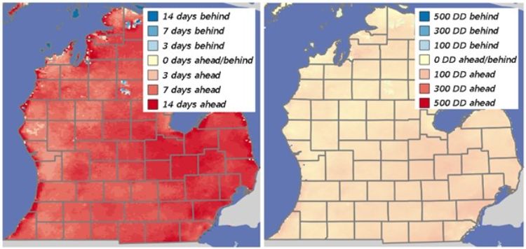
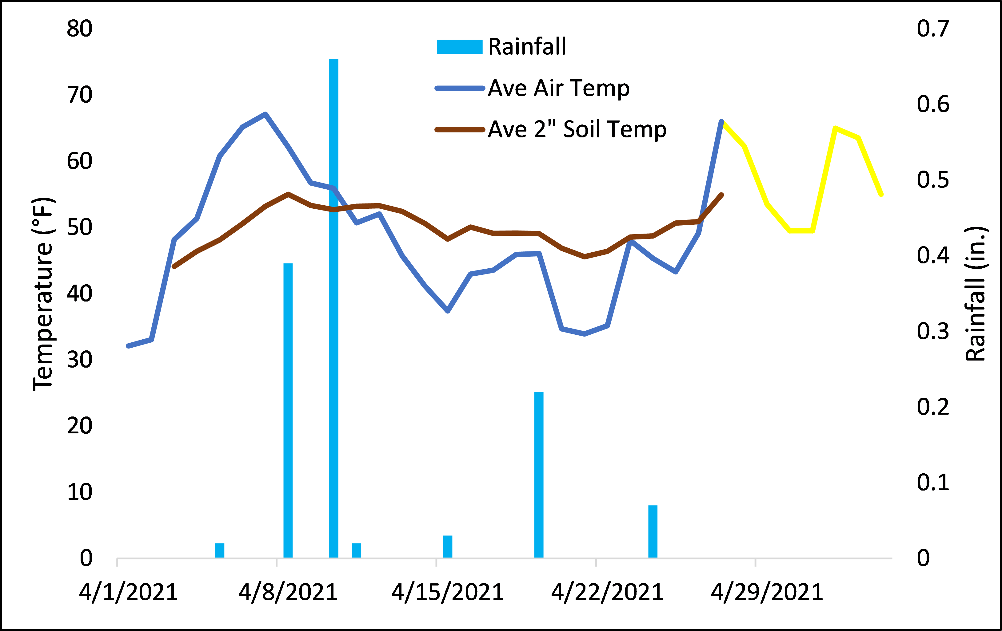
What a difference a couple of weeks can make. Although we were off to an early start to the season with dry conditions and much-above-normal temperatures in late winter, the cooling trend during the last half of April has brought our heat units much closer to normal, although we are still roughly seven to 10 days ahead. Soil temperatures did take a dip with many areas seeing average 2-inch depth temperatures go below 50 degrees Fahrenheit, but they have rebounded with the warming trend this week. There is a chance of a light frost overnight Friday in low-lying areas as temps dip down to 35 F. Even with the cooler temperatures today and tomorrow, soils should remain above 50 F moving forward.
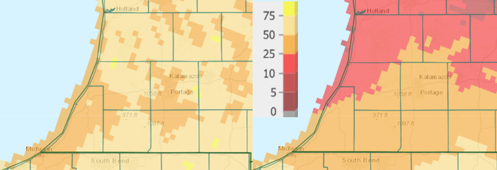
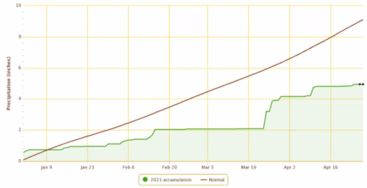
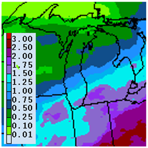
The southwest region has continued to fall further behind with regards to precipitation with most areas receiving between 5 and 50% of normal rainfall over the past two weeks. The situation for Michigan continues to deteriorate as nearly all the Lower Peninsula and eastern Upper Peninsula are now classified as being under a moderate drought. As an example, precipitation received in Coldwater, Michigan, is currently 4 inches below normal, evidenced by dust clouds rolling behind tillage equipment and planters in the area earlier this week. Michigan State University Extension and Purdue University Extension irrigation educator Lyndon Kelley has described the drought challenges in a recent article with the recommendation to monitor local water table levels as the spring progresses, particularly for those using irrigation.
We may see some improvement to the situation with the upcoming rainfall forecast. The storm front passing through over the past 24 hours did deposit as much as 0.50 inches along the Indiana border with totals dropping to less than 0.10 inches further north. The region may see as much as an additional 0.25 inch today, but the next good chance of precipitation will come early next week with a tropical-origin weather system that should arrive on Monday and deliver as much as 2 inches over a two-day period. The medium-term outlooks have been adjusted overnight with near-normal temperatures predicted for the first half of May. All models are predicting wetter than normal conditions for that period.


Crops
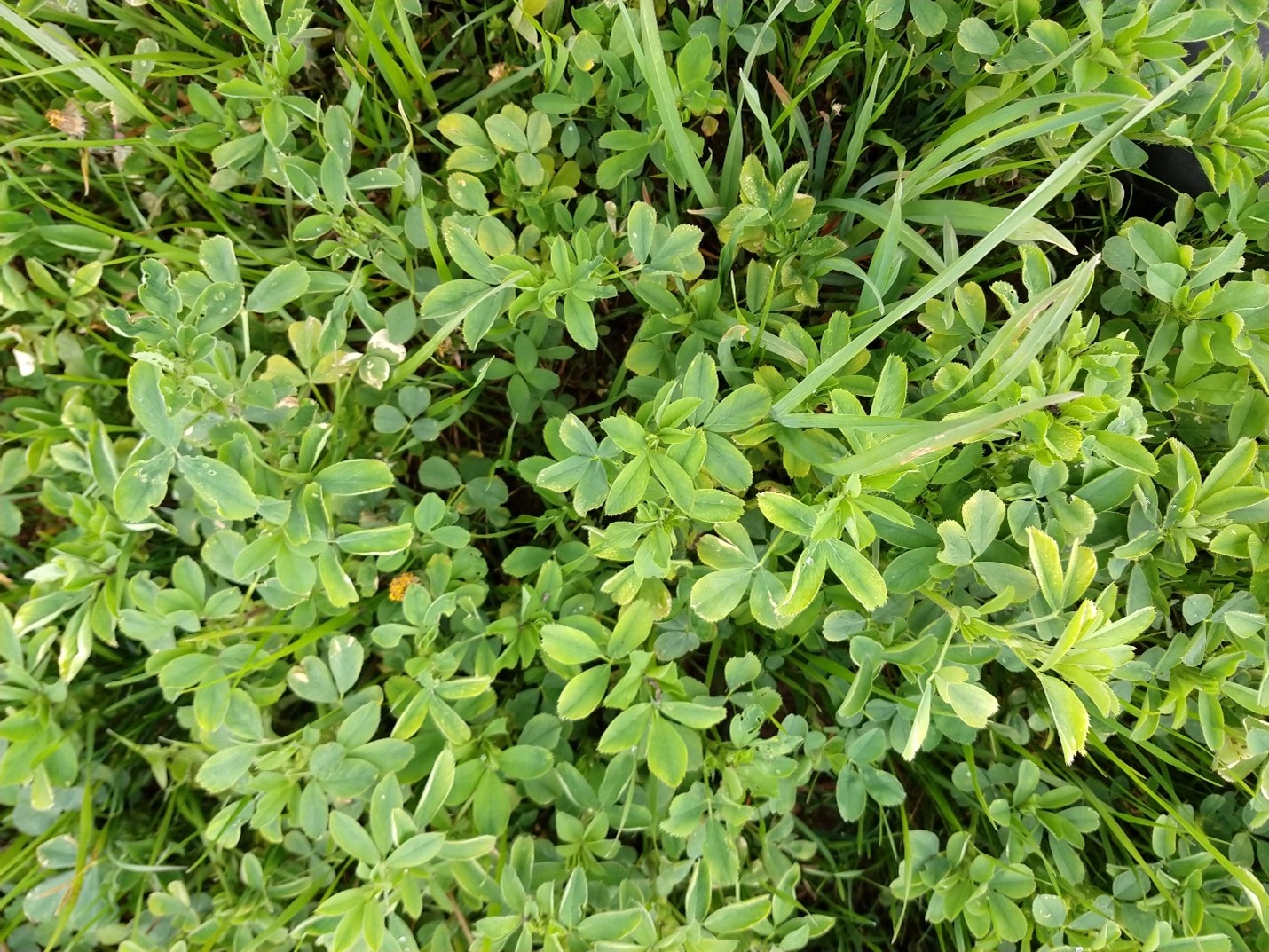
Winter wheat and alfalfa appear to have come through last week’s freezing temperatures relatively unscathed. The extreme cold temperatures (20.8 F near Paw Paw, Michigan) that we saw on April 21 and 22 have begun to show symptoms (yellowing, tip and edge burn, some stem wilting) on area alfalfa fields, particularly in the western side of the region. While we do not expect long term or sustained damage, it may be good to step up your insect scouting for alfalfa weevil and potato leaf hoppers (when they arrive here) to make sure the fields impacted do not experience additional stress during the first and second cuttings.
Tillage equipment, sprayers and planters continue to make progress, although the state is only a few percent ahead of normal with regards to corn and soybean planting according to USDA’s recent Crop Progress Report.
Wheat has just started jointing (Feekes 6, indicated by the presence of the node “bump” near the base of the main stem) in our region. Why is that important? Jointing marks the last time for wheat when a late nitrogen application can be made with minimal risk of injury. There are also herbicides that cannot be safely applied once wheat has jointed, including dicamba and certain ALS-inhibitors (Outrider, Olympus, PowerFlex, Rave, etc.). Other herbicides can be used until boot stage (2,4-D, MCPA, Starane Flex/NXT, Finesse, etc.) and others can be used through flag leaf (Affinity BroadSpec/TankMix, Ally Extra SG, Harmony, Huskie, etc.). Check the label on herbicides you are considering for growth stage restrictions.
Fields with cover crops and winter annual weeds can still be found although an estimated 75% have been terminated. In the recent article, “Cover crop termination timing to help manage soil moisture,” Kelley estimated that as much as 2-3 inches of additional irrigation (or rainfall) would be needed to make up for water removed by a dense cover crop and subsequent tillage.
Pests
According to MSU field crops entomologist Chris DiFonzo, alfalfa weevil monitoring should be underway soon based on accumulated heat units. This could be problematic as the pest may be progressing faster than the crop this year, resulting in a surge in the population well ahead of first cutting. Purdue entomologists Christian Krupke and John Obermeyer included an article and a scouting video on alfalfa weevil in their most recent Pest and Crop newsletter. Purdue Extension forage specialists are recommending planning for first cutting to be impacted and to consider planting annual forages to cover the possible shortage. If taking that route, it is important to order seed now as supplies could run low this spring.
Black cutworm and true armyworm continue to be a non-story so far this spring with no captures this past week in traps placed in St. Joseph and Kalamazoo counties. Reports of a few moths of each species being captured in east central Michigan came in this week. Aside from a surge of true armyworm catches during the second week of April in LaPorte County, Indiana traps have also been pretty quiet. As a reminder, true armyworm females blown in on northerly winds will look to lay eggs in grass crops/weeds while black cutworm will target fields with dense, low-lying broadleaf plants.
