Scientists meld Twitter and satellite views to understand epic impact
 Print
Print Email
EmailA unique look at two enormous global projects to understand if early concerns about environmental damage emerged, and public sentiment.
Scientists are using two bird’s-eye views – remote sensing from satellites and the voices of Twitter – to synthesize the environmental impacts of sprawling infrastructure projects and how the people who live amongst them feel about the changes.
In this week’s Environmental Science & Policy, scientists from Michigan State University take a unique look at two enormous global projects that are part of China’s Belt and Road Initiative, in part to understand if early concerns about environmental damage emerged, and if public sentiment turned critical.
“As large infrastructure projects profoundly influence the telecoupled human-nature world, it is crucial that we

develop new ways to evaluate both how nature is doing, and how people are perceiving these big changes,” said Jianguo “Jack” Liu, Rachel Carson Chair in Sustainability and director of MSU’s Center for Systems Integration and Sustainability. “No longer can a measure of only one or other be sufficient to achieve global sustainability.”
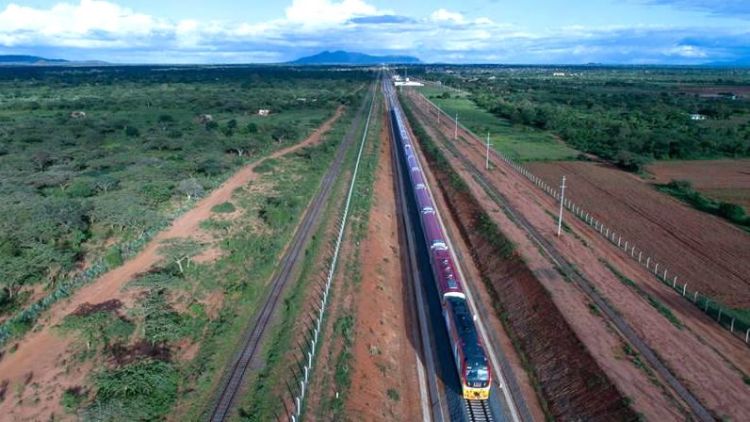
The research team, which included geographers, ecologists, environmental journalists and urban planners, designed and implemented a novel approach to understand the changes brought by two elements of China’s Belt and Road Initiative, which as a whole strives to build a network of transportation and economic centers connecting more than 180 countries across East Asia, Europe, and Africa.
They examined the Mombasa-Nairobi Standard Gauge Railway projects in Kenya and the China-Pakistan Economic Corridor (CPEC) in Pakistan to see how the landscape has changed in these projects, how the public perceived these projects and if public sentiment changed over time, in response to environmental changes.
The group examined satellite images of the vast areas the projects covered to see how forests, grassland, bodies of water and other land types changed. They combined that with nighttime light imagery as a way of gauging economic changes. More lights visible from far above means more economic development.
They combined this data with Twitter data, which can be tied to regions and issues, using carefully chosen keywords and hashtags to understand communication before, during and after the construction projects.
“Our analysis shows that both projects have led to a substantial loss of natural land but gains in artificial land,” said Yingjie Li, a PhD candidate at MSU-CSIS who is the paper’s lead author. “Despite this, we found that, overall, public sentiment toward the projects was largely positive and improved over time, which contradicts the prevalent pessimism by the Belt and Road Project critics. However, we further found that people in developed regions tended to show more and growing positive sentiments than people in other less-developed regions.”
Their exam learned that, particularly in Kenya, natural land gave way to more agricultural land – an enterprise made more appealing with easier access to a railway. Pakistan, too, showed that natural lands like forests and shrubs buffering the transportation lines, giving way to artificial land and, as its glaciers melt, increases in wetlands.
Their scrutiny of social media learned people in both Kenya and Pakistan were tweeting more about social and economic issues, peppering their messages with terms like “debt,” “corruption” or “cooperation” than environmental concerns.
Li noted that it appeared the people in more developed areas of Kenya and Pakistan were more positive about the sweeping changes than people in less-developed reasons. The paper also notes this early way of merging changes with opinions has limitations. The analysis was done on messages framed in English, and Twitter, while widespread across the world, does not reach every person.
“To sustainably build resilient infrastructure and advance human welfare while conserving ecosystems, which are among the United Nations’ Sustainable Development Goals, we’re putting out an efficient and integrated approach to help monitor both the social and environmental impacts of infrastructure projects operating at large scales and across the globe,” Li said.
In addition to Li and Liu, “Synthesizing Social and Environmental Sensing to Monitor the Impact of Large-Scale Infrastructure Development” was written by Yuqian Zhang, Leigh Anne Tiffany, Ruishan Chen and Meng Cai.
The work was funded by the MSU Environmental Science and Policy, the National Science Foundation, the National Social Science Fund of China and the China Scholarship Council.