High winds damage Ottawa County nursery
Editor’s note: This article is from the archives of the MSU Crop Advisory Team Alerts. Check the label of any pesticide referenced to ensure your use is included.
Editor’s note: This article is from the archives of the MSU Crop Advisory Team Alerts. Check the label of any pesticide referenced to ensure your use is included.
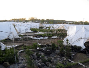
From its appearance and the damage it caused, it almost appeared as if a small tornado had moved through Lincoln Nursery in Ottawa County last Sunday afternoon (See image). However, tornadoes are always associated with severe thunderstorms and the weather last Sunday in western, lower Michigan was sunny, cool and windy. The culprit, in this case, was a dust devil, a weather phenomenon more typical in the southwestern U.S. Dust devils are a relatively small, but well-developed, rotating dust whirls, usually of short duration and rendered visible by dust, sand and debris picked up from the ground.
Dust devils form when hot air near the surface rises quickly through cooler air above it due to differences in density (think hot air balloon). If conditions are right, the air may begin to rotate. As the rotating air rises, the column is stretched vertically, causing intensification of the spinning effect by the conservation of angular momentum, like a figure skater. At the bottom of the circulation, more hot air rushes in toward the developing vortex to replace the air that is rising, and the circulation may further intensify and become self-sustaining, as long as the source of the warmer air at the surface is available. This is one major difference with its distant cousin, the tornado, in which circulation is largely driven by winds above the surface and the vortex circulation usually originates near the updraft of a thunderstorm and develops downwards towards the surface.
The circulation of a dust devil is in essence a very localized area of low pressure with air moving into the center of circulation near the surface, then upwards in the column, then outwards once again at the top of the circulation. Once the dust devil loses its original source of hot air, it dissipates rapidly, usually within seconds.
Dust devils are typically on the order of a few feet to 100 feet in diameter, and their circulation may reach a few hundred feet or more into the atmosphere. There are four major factors in the development of dust devils:
- Strong sunshine under mostly clear skies: solar radiation-heated surfaces are the primary source of the heat energy needed to initiate vertical motion in the atmosphere.
- Relatively cool air above the surface, which leads to greater potential atmospheric instability enhancing the rising motion of air.
- Light winds as winds across a surface tend to: a) increase thermal mixing of the atmospheric boundary layer, reducing the surface heat imbalance and the degree of stability or tendency of air to rise; and b) act to prevent formation of localized vertical and horizontal rotary circulation motions, similar to what happens with tropical storms and hurricanes on a much larger scale.
- Dust devils are most common in areas of flat terrain where surface heating is more consistent and topographical or surface cover features do not interfere with localized circulation.
Given these requirements; dust devils are most common on hot, relatively calm afternoons with clear skies in flat, open areas where intense surface heating leads to large differences in temperature in the atmosphere just above the earth’s surface. Geographically, they may occur almost anywhere, but are relatively most common in arid desert and semi-arid regions. Maximum winds in a dust devil typically remain below 45 mph, but on rare occasions, stronger winds in excess of 60 mph are possible. As evidenced last Sunday (May 17), strong dust devils can cause significant property damage, and while very rare, have been associated with fatal injuries.
Damage from the Ottawa County dust devil event last Sunday is clearly evident in accompanying photo. The main damage path appears to have been approximately 25 to 30 feet wide. The plastic covering material from several poly-houses was ripped off of its steel tubing frame and the plant material inside was scattered. Even more impressive, the steel frame of the first structure hit (visible in the image foreground) was severely bent or destroyed and heavy railroad ties inside the structures were picked up and moved from their original locations. Fortunately, no injuries were reported during the event.
Looking at weather conditions last Sunday afternoon when the event occurred – approximately 3PM local time – most of the necessary factors were in place. There was strong sunshine for several hours up to the event – solar radiation values in the 2 to 3 hours preceding the event were over 900 watts/m2, near the upper limit of what is typically observed in Michigan during the summer season. Cool air was aloft with freezing temperatures only a few thousand feet above the surface, and the location was a relatively flat landscape. However, one condition was notably absent: relatively calm winds. The closest Enviro-weather station in nearby Hudsonville recorded consistent 10 mph or greater winds out of the west-northwest most of the afternoon, which should have hindered dust devils from developing. One possibility would be buildings, trees, or some other windbreak feature that led to a relatively sheltered area on the landscape which allowed the circulation to form and strengthen.

Wind damage at Lincoln Nurseries, May
17th 2009. Photo credit: A de Wit, Lincoln Nurseries.
Dr. Andresen's work is funded in part by MSU's AgBioResearch.


 Print
Print Email
Email

