Northwest Michigan fruit update – April 20, 2021
 Print
Print Email
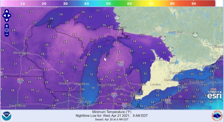
EmailTwo nights of predicted below freezing temperatures are concerning for fruit growers.
Weather report
The weather seems to be on everyone’s minds with the early season and the predicted cold temperatures for the next two nights. There are flurries in the air as we write this report. Tree development is quite far along for April 20, so cold overnight temperatures are certainly a concern. The weather is predicted to be partially sunny but much cooler today and into tomorrow and Thursday. More flurries are also in the forecast. There are predicted freezes tonight and tomorrow night, but these cold temperatures will be accompanied by wind today (April 20) (Figure 1). They are predicting advective freeze conditions for tonight into tomorrow morning; somewhat calmer conditions could result in an inversion for overnight on Wednesday, but the forecast is not currently calling for a strong inversion.
At the beginning of this month, climatologists were predicting warmer and drier conditions for April. However, these forecasts have changed, and the medium range forecast is now predicted cooler and wetter conditions as we move into May.
Despite the recent cool weather, we are still considerably ahead of our normal conditions. Things have slowed significantly with the colder weather, and Michigan State University Enviroweather station records of growing degree days (GDD) indicate we are at 235 GDD base 42 and 103 GDD base 50. Some growers are still saying they are two to four weeks ahead of where they were last year. Current and forecast GDD from Enviroweather can be found in Table 1.
The region did receive rainfall last week. The Northwest Michigan Horticulture Research Center Enviroweather station recorded 0.17 inches. There were also trace amounts of rain yesterday, April 19. The rainfall predictions are low, and for the next week there is at most a 50% chance of rain throughout the region.
View MSU climatologist Jeff Andresen’s weather report.
|
Table 1. Northwest Michigan region current and forecast GDD from Enviroweather. | ||||
|---|---|---|---|---|
|
Enviroweather station |
GDD Base 42 F Current (4/20) |
GDD Base 42 F Forecast (4/26) |
GDD Base 50 F Current (4/20) |
GDD Base 50 F Forecast (4/26) |
|
Benzonia |
251 |
272 |
113 |
118 |
|
East Leland |
237 |
261 |
103 |
109 |
|
Eastport |
251 |
274 |
114 |
120 |
|
Elk Rapids |
245 |
299 |
126 |
132 |
|
Kewadin |
294 |
317 |
138 |
145 |
|
Northport |
194 |
214 |
77 |
81 |
|
Old Mission |
243 |
267 |
103 |
109 |
|
Onekama Twp/Bear Lake |
236 |
256 |
108 |
112 |
|
Petoskey |
240 |
255 |
106 |
108 |
|
Traverse City (NWMHRS) |
249 |
273 |
107 |
113 |
|
Williamsburg 20m Tower |
270 |
294 |
127 |
133 |
Crop report
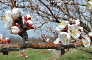
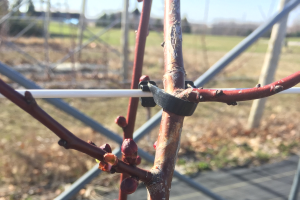
There have been lots of calls about the cold weather’s impacts on bud development. We have heard reports of limited damage in sweet cherry and a bit of damage in tart cherry in certain areas of the region. However, at this point, much of the crop is still looking good. These upcoming cold events are certainly a cause for concern. Tart cherries are at the elusive water bud stage, which has traditionally been a more susceptible stage of development.
The weather is also predicting wind associated with tonight’s cold weather, and this freeze will not be a typical inversion event. Be cautious if you are planning to use wind machines. In a situation where we do not have an inversion type freeze event, frost fans can decrease temperatures even more than not using the machines at all. Additionally, with the cold temperatures they are predicting, there will be no warm air from which to pull down into the orchard with wind machines.
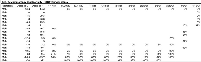
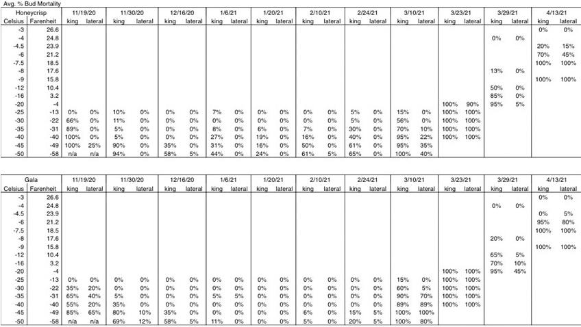
Based on our programmable freezer data, the following charts show the temperatures where we expect damage in tart cherry (Figure 2) and apple (Figure 3). We collect apple and cherry buds at the Northwest Michigan Horticulture Research Center, and we place them into our programmable freezer at the different temperatures. We pull buds out every two hours as the temperatures drop, and we cut open the buds and evaluate bud mortality at the different temperatures.
We collected tart cherry buds on April 15, and we see 3% damage at 23.9 degrees Fahrenheit and 92% damage at 21.1 F. In apples, we collected buds on April 13, and we start to see some damage in Honeycrisp at 23.9 F. Damage increases significantly at 21.1 F, and we observed 45-70% damage, and by 18.5 F, we observed 100% mortality in Honeycrisp. Similar trends in bud mortality were observed in Gala as well: 100% mortality at 18.5 F. At this time, it is difficult to predict the overnight lows, so we will hope for the best for the next two nights.
Pest report
Since green tip (April 5) in apples, there has been one major primary apple scab infection period in the region during wet weather that began on April 8 and spanned a few days depending on location. Another couple of days of wet weather from April 14-16 resulted in a few infections scattered across the region. Because temperatures were so cold, some areas were not wet for long enough to trigger an infection. Similarly, rainy/sleety/snowy weather on Monday, April 19, was too cold and the infection period too short to result in an infection.
If an infection occurred during the first major scab event, symptoms are estimated to show up during the first week of May. Cool temperatures will continue to inhibit tree development, but warmer, sunnier weather is ahead for Thursday and Friday, which could stimulate growth. Rain is currently predicted to follow warmer conditions at the end of the week, and the warmer the average temperature during wet weather, the faster an infection period can occur. The About the Model tab on Enviroweather provides a table that describes the approximate wetting period required for primary apple scab infection at various air temperatures. This table is a quick reference for curious minds to calculate the risk or chance of predicted weather to result in an infection period.
In addition to Enviroweather, our MSU fruit team is offering the apple scab model through RIMpro. These models are available for various fruit growing areas including one for Romeo, the Southwest Michigan Research and Extension Center in Benton Harbor, four locations on the Ridge, one in Hart and three locations in northwest Michigan. For the northwest region, the model output links for Benzonia, East Leland and Williamsburg are below. Each of these outputs is linked to the Enviroweather stations in those locations so the outputs and forecasts should be consistent across both services.
The outputs change as forecasts change, so be sure to check the outputs frequently to best assist your management decisions. An article with links for all of the RIMpro model outputs and how to interpret them is forthcoming.
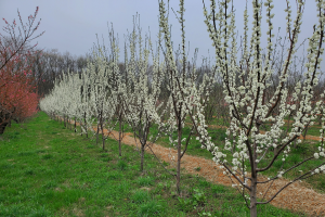
Sweet cherry flower buds have shown a little progress since last week with most of the development occurring over the weekend. Signs of white flowers are starting to show on Ulster and Emperor Francis, whereas flower buds on Golds are still tight. Growers and the Northwest Michigan Horticulture Research Center have been experiencing the “hurry up and wait” scenario as initial warm conditions quickly turned to cold weather. The sweet cherry full bloom estimate is slowly getting pushed back and is currently predicted for April 27. While cold weather ahead is the top concern currently, continue to watch flower bud development, particularly as temperatures warm toward the end of the week, to help estimate when popcorn or bloom protection may be needed.
Tart cherries, particularly Montmorency, seem to be at a standstill in terms of development. Balaton showed slightly more progress over the weekend from late bud burst on Friday, April 16, to early tight cluster on Monday, April 19. As noted previously, continue to watch development closely to estimate when the first fungicide applications may be needed in tarts.
Currently, this spring is shaping up to be concerning for European brown rot if conditions continue to be cold and are wet during bloom. We have not observed serious European brown rot challenges in recent years, but in the past, this disease has caused significant losses in Balaton orchards (which are more susceptible than Montmorency), and in slow drying Montmorency blocks.
It is still early for cherry leaf spot protection, but as mentioned last week, we have observed bract leaf infection before bloom under optimal disease conditions in previous seasons. If you missed the American Brown Rot and Cherry Leaf Spot Fungicide Resistance Management presentation by MSU’s George Sundin and Nikki Rothwell during the 2021 Statewide Spring Tree Fruit Webinar series, it is worth reviewing on our team’s MSU Kaltura page to learn more about our observations of early season cherry leaf spot infection and management options in light of resistance. The entire series was recorded and can be viewed at 2021 Spring Tree Fruit Webinar Series.
Cold temperatures have continued to result in little insect activity overall. Green fruitworm adults were active over the weekend with an average catch of two moths, down from 23 last week. According to growing degree days (GDD), we are past the peak emergence and small larvae could be present. We have not observed green fruit worm caterpillars at the station yet this season.
We have not observed plum curculio at this time, but we have received questions about plum curculio activity as beetles could be emerging according to GDD base 50 F. In the recent past, this pest has been tricky to manage early in the season particularly in apricots and hot spot orchards. In previous years, warmer weather during bloom and petal fall facilitated quick fruit growth that overlapped with a flush of plum curculio activity. As with other insects, cold temperatures influence the behavior of this pest and current 2021 springtime conditions will likely delay plum curculio activity. However, as soon as temperatures warm and fruits are coming out of the shuck, be prepared to take action against this pest, especially where the beetles have been problematic in the past.
No American plum borers have been found in our traps over the past two weeks. Emergence is estimated around popcorn in tart cherries or 118 GDD base 50 F.
For the second week in a row, we have not found oriental fruit moth and spotted tentiform leaf minors are active in apples in low numbers.
We began trapping for black stem borer and caught a total of two beetles over the past week.