Northwest Michigan fruit update – April 30, 2019
 Print
Print Email
EmailCold temperatures have slowed tree fruit development and growers are balancing early season insect and disease control with tree growth.
Weather report
We thought spring had arrived for a few days last week, but we are still enduring cold and wet conditions for most of this week. Michigan State University’s agricultural meteorologist Jeff Andresen is predicting some sunshine for the weekend, but cool and wet weather will return for the first full week of May. We have added a recording of Andresen’s weather report, which will be available on Tuesday afternoons on MSU Extension’s Weather for Fruit & Nuts page.
With the cool conditions, our growing degree day accumulations (GDD) have slowed, and we are at about half of the GDD accumulations for 2019 compared with our 30-plus-year average. We have accumulated 121.4G DD base 42 and 45.9 GDD base 50; our averages for the Northwest Michigan Horticulture Research Center are 201.5 GDD base 42 and 83.9 GDD base 50.
We have been receiving calls about cherry bloom in northwest Michigan, particularly from our tourism colleagues. Based on Andresen’s forecast, we estimate bloom to be later than usual this season. In the most recent past, our tart cherry bloom has been moved up by seven to 10 days from around May 15 to closer to around May 7. However, this year we are likely going to bloom later in the season, perhaps closer to the third week of May. The slow start to spring weather—coming out of dormancy slowly—typically results in less chance for spring frost/freeze events.
Crop report
Trees are coming out of dormancy rather slowly, and we are observing green tissues on apples and side green in sweet and tart cherries. Growers have been trying to balance early season sprays with the cool weather conditions.
Pest report
Apple scab management programs are underway, and growers have been making applications preceding the wet weather this week. RIMpro Venturia models show potential for spore discharge events during mid-week rains, and infections are possible in these predicted extended wet conditions (see models below). Freezing temperatures overnight on Saturday, April 27, and Sunday, April 28, were not cold enough to cause damage to buds in most areas, but these freezing conditions have been a concern for oil applications. Oil should not be used 48 hours before or after frost or freeze conditions as it can cause damage to green tissue and buds in extreme cold (or hot) temperatures. The latest freezing temperatures were on the morning of April 28; most areas should be in the clear at this time.
Also, keep in mind that Captan should not be used within several days of oil due to the potential for phytotoxicity, and future scab sprays should be planned accordingly. Lastly, copper applied as late as half-inch green or later can cause fruit russet.
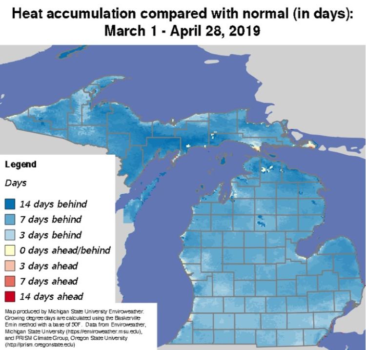
As mentioned previously, cherry development has also halted due to cold temperatures. This slow start to spring has pushed back our typical development, meaning disease programs for cherries are also delayed. Currently, MSU Enviroweather is suggesting the majority our region is approximately seven days behind normal in most areas of the northwest Lower Peninsula (Fig. 1).
In the last week, pollinators have been active during warmer days, but insect activity as a whole has been slow due to cold wet weather. We set traps for oriental fruit moth at the station last week, but we have not caught any moths. In the coming week, we will begin monitoring for black stem borer, American plum borer and San Jose scale.