Northwest Michigan fruit update – May 17, 2022
 Print
Print Email
EmailWith the recent hot weather, we blew through sweet cherry bloom, and many farms are in tart cherry bloom or at early petal fall; apples are also opening but will slow with the cooler temperatures in the forecast.

Weather report
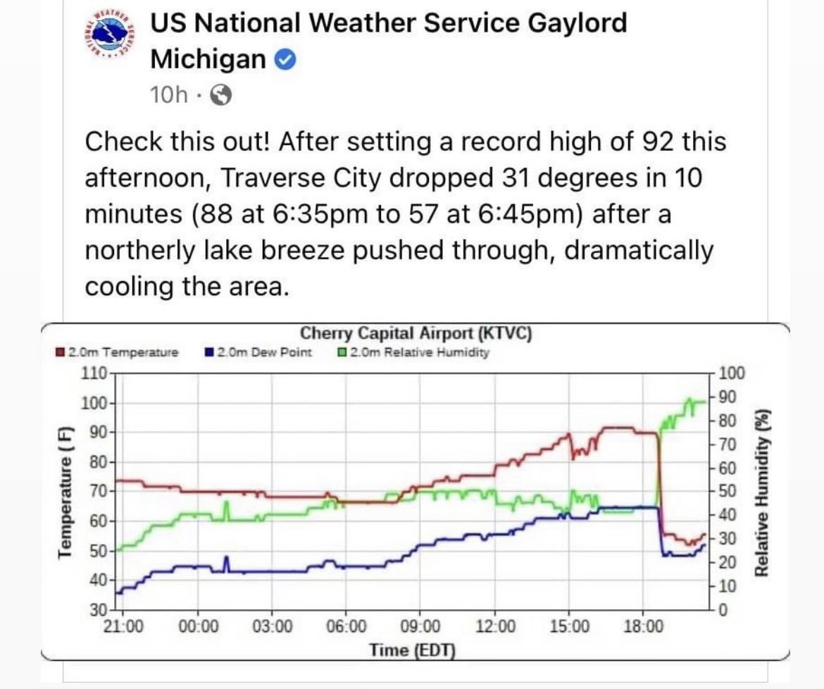
The most notable weather pattern this past week was the extremely warm weather we had across the region. The northern part of the state was even hotter than other southerly areas of Michigan. The high temperature of 96 degrees Thursday shattered the record high for May 12 in Traverse City, according to the National Weather Service. Previously, the highest recorded temperature for that day in the area was 86 degrees, set in 1944. Thursday also set the all-time warmest temperature in the month of May for Traverse City and the earliest time in the year in which Traverse City hit 95 degrees or warmer. Prior to this year, 95 degrees was the highest May temperature for Traverse City and the earliest temperature reading of 95 or above in the city was on May 20, 1977. Another interesting situation that happened in the north was the high temperatures on 16 May that reached 92 F, and then the wind shifted and came from the north across Grand Traverse Bay, and the temperature dropped 31 F in 10 minutes (Figure 1).
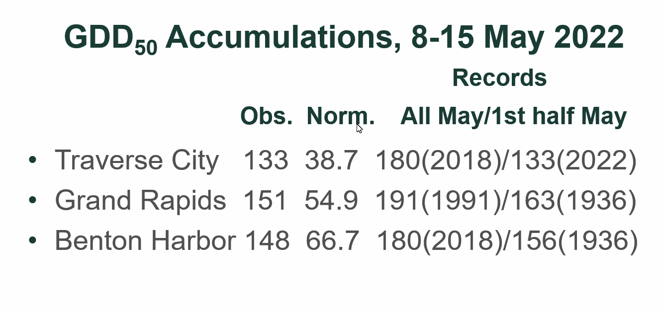
Jeff Andresen pulled out some interesting data about the accumulations of growing degree days (GDD) for 8-15 May, 2022 for three areas of the state: Traverse City, Grand Rapids, and Benton Harbor (Figure 2). Notably, our area had significantly more GDD accumulations than normal; we observed 133GDD base 50 this year compared to our normal accumulations of 38.7GDD base 50.
We have accumulated 398GDD base 42 and 213GDD base 50 for the NWMHRC. With the recent heat, we have surpassed our base 50 accumulation average, which was 173.5GDD compared to the 2022 accumulations of 213GDD. Our accumulations average for base 42 is 381.2GDD.
Our region has had very little rain thus far in May, and conditions are extremely dry. Based on the upcoming forecast, there is a chance of rainfall tomorrow 18 May and again on Friday, 20 May. However, the chance of rain decreases further north than in the southern part of the state where most of the rain will fall; the north is forecasted to receive a quarter to less than a half inch of rain. Southern Michigan is predicted to have a more gradual, longer lasting rain than the very scattered chances in the north. Rain is predicted to begin in the western part of the state tomorrow (18 May) and move across the state through the day and end in the evening. Thursday is predicted to be warmer than today or tomorrow, and rain may move back into Michigan again on Friday (20 May). Friday will be the warmest day of the week. Rain may persist into Saturday morning with possible scattered showers. Cool and dry and partly sunny in the north.
Crop report
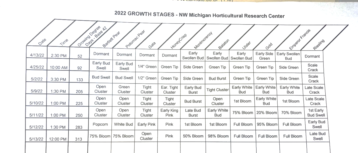
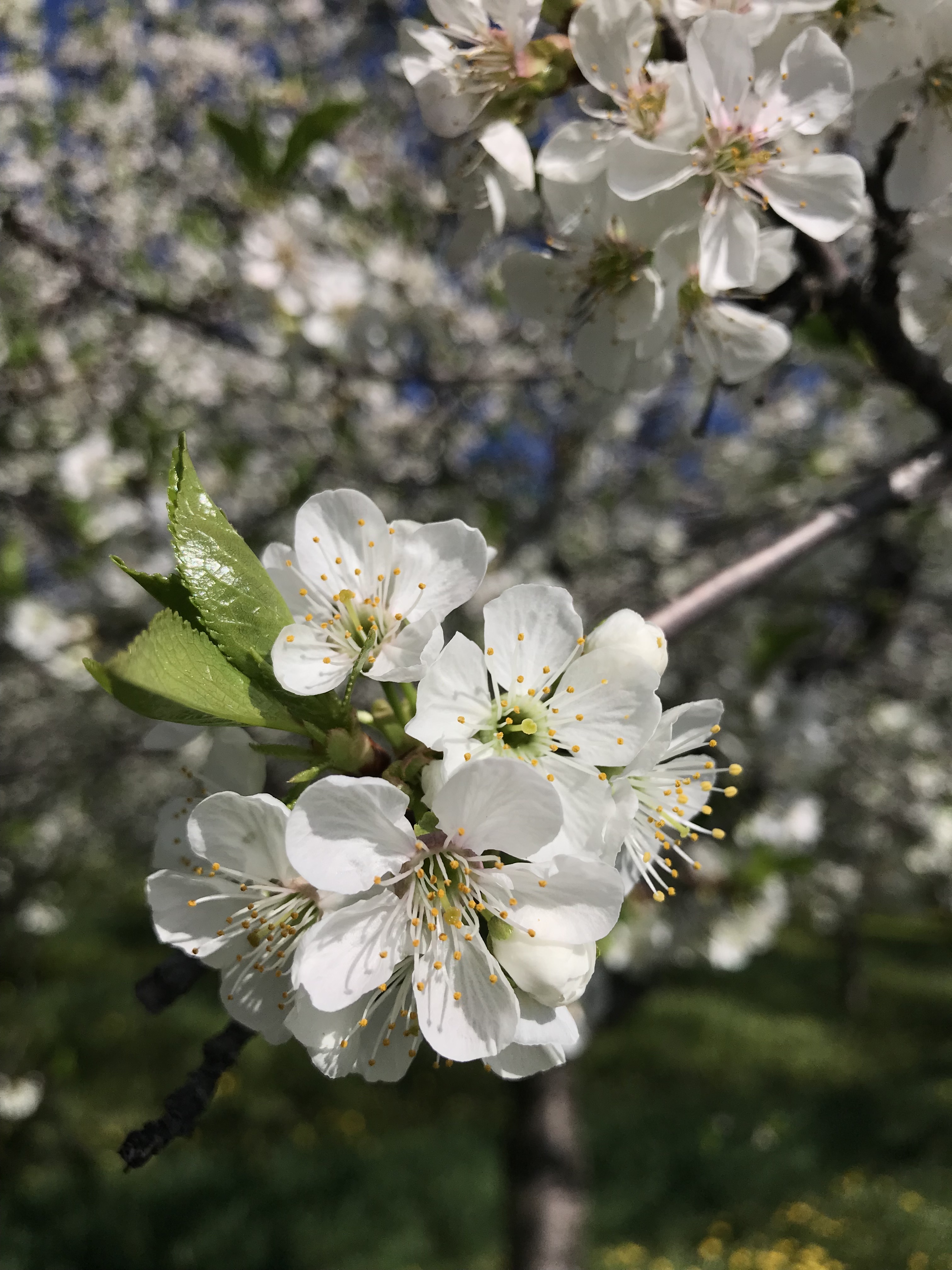
The hot weather moved crop development along super quickly last week. With the cooler weather moving back into the region, development will slow, and unopen blossoms will open slowly rather than the ‘open before your eyes’ pace we saw last week. Looking back our growth stage observations last week were remarkable (Figure 3). In sweet cherry, we were in green tip in Ulster on 2 May, and by Friday 13 May at noon, we were at full bloom. We were trying to count blossoms for a sweet cherry thinning trial, and the task became increasingly more difficult as each hour went by on the afternoon of 11 May. As of yesterday morning, 16 May, we were at petal fall in all sweet cherry varieties. We saw a similar situation in apple, where Gala and Honeycrisp were in green tip to half inch green on 2 May, and we observed open bloom by 13 May, Friday at 4 p.m.
Amy Iezzoni is currently doing some pollination work at the NWMHRC, and she thought that we had potential for a very nice crop of tart cherries. Even with the damage we documented (35% mortality in tarts) from the April cold events, she thought many of the blossoms were healthy and had the potential to set well. The biggest issue would be active pollinators. With the hot weather, the bees had a relatively short amount of time to do their pollinating work. However, bees were particularly active all last week and into the weekend with the warm and sunny conditions.
Apple bloom will continue through this week with the cooler weather. Although temperatures will be much colder than last week (~20+ F), conditions will still be excellent for honeybee activity. Honeybees are most active between 60 and 105 F, though they can forage at temperatures as low as 55 F. Honeybees also prefer to forage when winds are down. To maximize honeybee foraging activity, especially in a time when we need fast pollination action during a quick bloom, growers should reduce dandelions in an orchard. In more normal circumstances (i.e. moderate temperatures and longer bloom windows), a variety of pollen sources can improve honeybee hive strength and bee health.
Insect pest report
With the warm weather, insect activity has ramped up, as expected. One note from the MSU Fruit Team is that plum curculio have been extremely active already this season. This pest prefers warm and humid nights, which we had across the state last week. We have not observed this pest in our region but wanted to keep growers informed that this pest seems to be on the move already this season in the south. Pests will slow with the cool weather.
Green fruit worm. We caught an average of 22 moths per trap this week, which is up from 12 last week. Many growers consider this pest minor, but they can cause some feeding damage in cherry orchards.
San Jose scale. We caught our first male SJS this week, but very few. This pest will slow again (as will others) with the cool weather. Growers that missed their oil sprays should consider Sivanto or Centaur to target SJS. Movento should be used when we have more leaf area to take up this mobile material.
American plum borer. We caught an average of 2.7 APB moths this week, which is our first catch of this pest this season.
Black stem borer. We have been trapping for BSB at the station this season, and again, this was the first catch of this insect this season on Monday, 16 May. If growers have had problems controlling BSB in the past, they should target control materials at peak male flight, and this flight has only just begun; growers should watch numbers and their rise to target their first BSB applications.
Oriental fruit moth. We caught an average of two OFM in our traps at the NWMHRC. They have been catching this pest down state, and they have called OFM biofix at the Trevor Nichols Research Station. OFM has not been a major issue in our region in the past.
Disease report
American brown rot. The window has closed for most orchards to apply Rovral for blossom blight. This material can only be used through petal fall in sweet cherry.
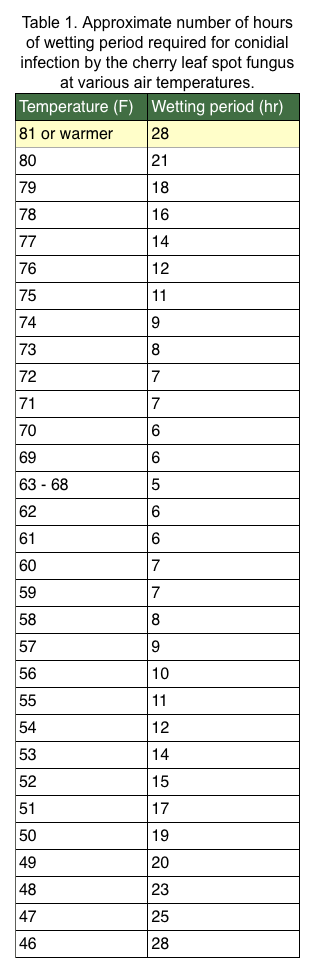
Cherry leaf spot. We are just starting petal fall in Montmorency at the station, while tarts are in full bloom to the north. At this time, there are bract leaves open on Monts, and growers should be watching the forecast for leaf spot infection. Again, growers might have a tough call with the predicted sporadic rain in the forecast and temperatures will be cool and this fungus is slow growing, especially in cooler conditions (Table 1). We would need at least nine hours of wetting to have a leaf spot infection if the temperature hits a high of 57 F tomorrow.
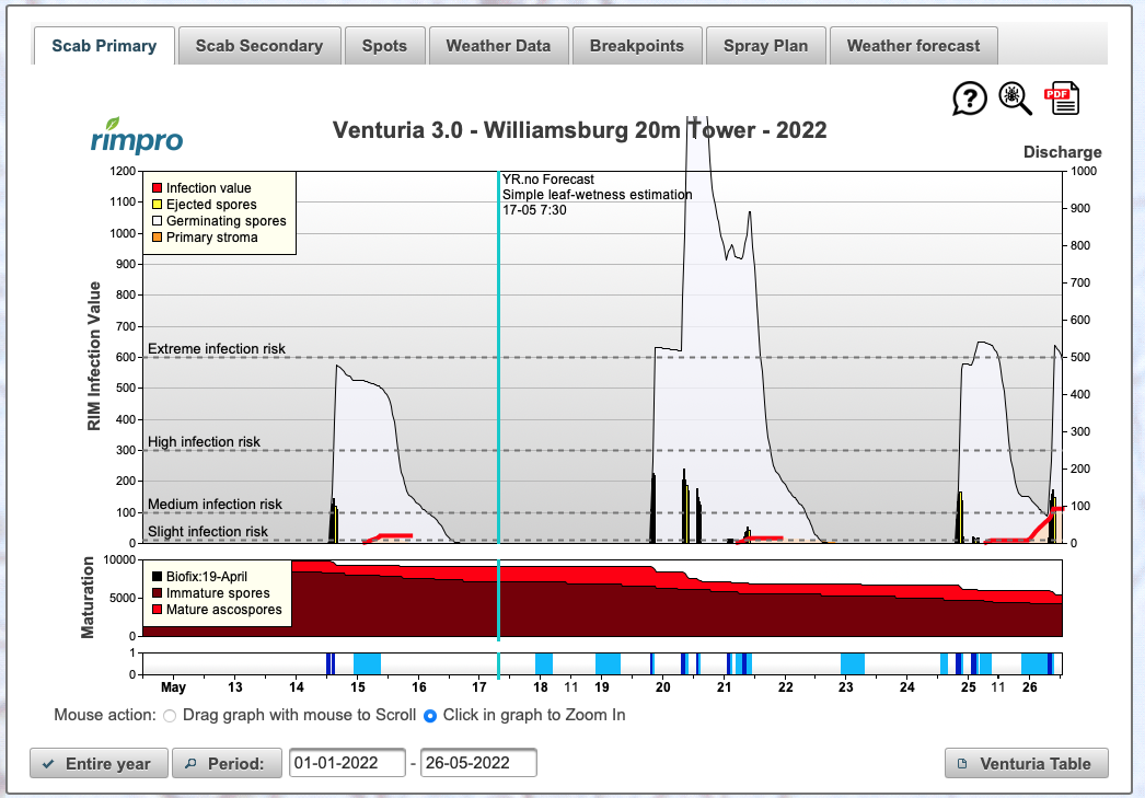
Apple scab. With the warm weather, apple growth and apple scab spore maturation have been accelerated. Growers have been using the current forecasts to best time scab sprays, and thus far, we have received very little rain to discharge scab ascospores. However, there are two good/better chances for rainfall this week: 18 May and again on 20 May. Growers need to be ready to make apple scab applications to cover tissue as the spore release will be very large with all the matured spores ready to go. Growers should monitor weather forecasts and be ready to protect against scab, but as Dr. Andresen eluded on the Fruit Team call that rainfall in northern Michigan is likely to be sporadic. Keep an eye on your local forecast! The RIMpro model is showing apple scab spore maturation but only a slight infection risk (Figure 4). This scab infection risk incorporates the rain forecast, and the forecast that the RIMpro model is using is showing only a slight chance of rain tomorrow. Again, growers should be ready to make a scab application if we do get rain—either tomorrow or on Friday, which is the next chance for rain in our area.
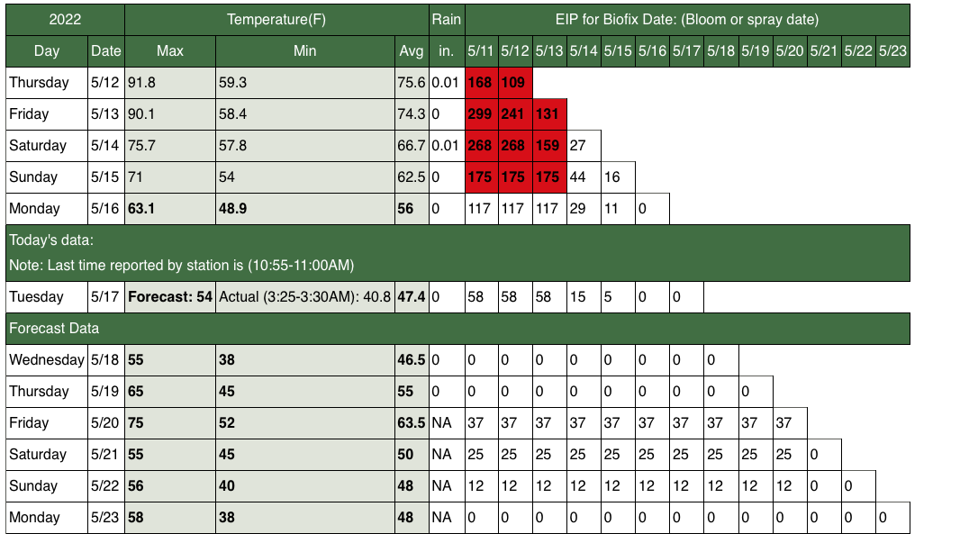
Fireblight. Apples are ~75% bloom at the NWMHRC, but with the cooler weather, the EIP for fireblight has dropped considerably from last Friday (Figure 5). Growers can relax about this disease until the temperatures start to rise again, which at this time, daytime highs are not expected to drive EIPs into risk levels through this weekend.