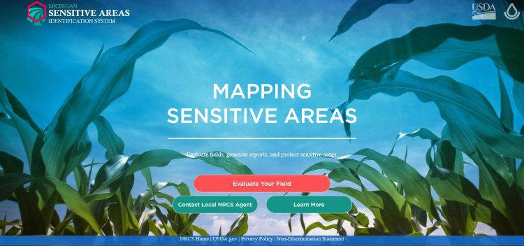
Online conservation planning tool outlines sensitive areas in fields
 Print
Print Email
EmailThe Michigan Sensitive Areas Identification System tool helps outline sensitive areas in agriculture fields and is available at no cost to Michigan farmers.
What is the Michigan Sensitive Areas Identification System?
The Michigan Sensitive Areas Identification System (SAIS) is an online conservation planning tool developed by the Michigan State University Institute of Water Research along with the United States Department of Agriculture Natural Resources Conservation Service, Michigan Office. This tool allows users to identify and map sensitive areas on their farm fields such as places in fields that are prone to runoff, erosion, and loss of nutrients.
How do you get started with SAIS?
To get started with SAIS, users will identify individual fields they want to evaluate. To do this, users will navigate to the field using an address or zooming. The user will then outline field boundaries on the map with SAIS tools. Drawing these field boundaries are necessary so that SAIS can later generate a report.
After drawing the specific field in which the user identifies sensitive areas, SAIS will ask a series of questions to hone-in on that field’s characteristics. Questions related to field and management practices allows the tool to showcase map layers where sensitive areas are located and problems may develop. In addition to map layers, a list of recommended field practices to mitigate the identified risks is generated.
How is this information used?
Information generated by the SAIS tool can be used to create a report that can be saved for record-keeping purposes. The report will include a summary of the results, maps, and potential conservation practices that can be implemented on that specific farm. To save a report, users will want to create their own account. All data is encrypted to keep account information safe.
Helpful resources
To learn more about SAIS, you can take a look at the SAIS Quick Guide that goes through step-by-step how to create a report; a SAIS Training Package outlining the background and reference material; a SAIS Training Presentation, which shows a system overview and walkthrough and applied tutorial; and lastly, a SAIS Flyer.
Conservation planning is important from both an economic and environmental standpoint. By identifying potential sensitive areas in farm fields, it allows for an adjustment in farming practices that help protect Michigan’s natural resources as well as save unnecessary money from being spent in areas of fields that cannot be utilized to their fullest potential. For more information or questions, please contact Michigan State University Extension’s Erica Rogers or Sarah Fronczak.