


Sample Wildfire Hazard Zoning helps communities protect against property and life loss
 Print
Print Email
EmailWildfires are common in Michigan, and individuals and local governments both play roles in addressing wildfire mitigation and protection to make communities safer.
 Michigan experiences an average of 8,000-10,000 wildfires each year. While most of these fires are small, each year wildfire damages property and risks human life. The 10 largest fires between 2006 and 2012 in Michigan consumed more than 60,000 acres and destroyed approximately 250 homes and other structures. Fortunately, individuals and communities can take steps to protect against wildfire and coexist with this naturally occurring phenomenon.
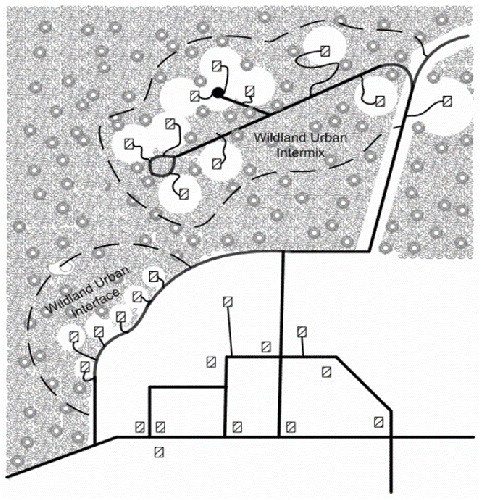
Figure at right – Graphical depiction of the wildland/urban interface and wildland/urban intermix (Source: http://www.douglas.co.us/building/documents/appendix-58-chapter-2.pdf).
In order to assist communities in developing strategies to reduce wildfire risk, Michigan State University Extension recently prepared Sample Wildfire Hazard Zoning for Michigan local governments. Local zoning, subdivision regulations, and other development standards comprise the rulebook by which homes, businesses, and other structures are constructed, arranged, and spread across the landscape.
For instance, the status and condition of vehicle access to developments and individual properties have bearings on the risk of wildfire loss. Private roads and driveways that are gated, too steep, too narrow, or offer no emergency vehicle turnarounds create situations where property owners are on their own and/or emergency vehicles are at greater risk if confronted by wildfire.
The Sample Wildfire Hazard Zoning presents four approaches that range from educating property owners in wildfire hazard areas to regulating property access, landscaping, and building materials. The range of approaches is presented for local governments to select the most appropriate option, based on local conditions and circumstances. In total, the four approaches are intended to allow any community with wildfire risk to incorporate Firewise principles in the zoning ordinance.
Approach 1: Wildfire Hazard Education
A simple amendment is made to the applicable permits article of the local zoning ordinance that requires anyone seeking a zoning permit for property located in an area with predominantly coniferous trees to be provided with educational resources that describe wildfire risk in Michigan and cover basic Firewise landscape and construction practices. The applicant simply signs off that he/she received the materials and is knowledgeable of the wildfire risk in the area. The approach is applicable to any jurisdiction with wildland, and is most applicable to rural communities with little staff capacity and/or little public support for additional land use regulation.
Approach 2: Wildfire Hazard Regulations to Ensure Property Access
The second sample approach includes the landowner education component for landscaping and construction related decisions and adds a requirement that driveways meet basic standards to ensure property access by firefighting equipment. The rationale for regulating driveway design is that public resources may need to access one’s property in the event of a wildfire and properly designed driveways ensure access to structures while protecting against firefighting equipment becoming stuck or damaged trying to navigate a private drive – a complication that could leave neighboring properties at greater risk. This approach is applicable to any jurisdiction with wildland and is most applicable to rural communities with little staff capacity, but public support for minimizing risks associated with provision of emergency services.
Approach 3: Wildfire Hazard Zoning through General Regulations
Like the second approach, this method includes standards for driveway design. This approach further regulates landscaping within three zones of defensible space surrounding a home up to 100 feet. Maintenance of landscaping, distance between mature trees, and the location of fuel storage is regulated. Further, Firewise construction materials and practices are identified to further reduce the risk of property damage from wildfire. This approach is most applicable to suburban communities with skilled staff and significant wildland/urban interface and/or wildland/urban intermix (see figure).
Approach 4: Wildfire Hazard Zoning as an Overlay District
The final approach uses identical standards as the third approach but identifies the properties that are subject to the wildfire hazard zoning standards through application of a wildfire hazard overlay district. The overlay district is determined by conducting a hazard assessment to identify and rank areas prone to wildfire based on characteristics such as vegetative types, soil types, topography, and weather. The hazard assessment is considered in addition to a more specific risk assessment that is based on such factors as available water supply, adequacy of road systems for firefighting access, and the availability of fire departments to respond to calls. The two spatial analyses taken together are used to map the specific boundaries of the wildfire hazard overlay district. This approach is most applicable to suburban communities with skilled staff, significant wildland/urban interface and/or wildland/urban intermix, and resources to map and keep updated a wildfire hazard area overlay district.
MSU Extension has made Sample Wildfire Hazard Zoning available for download at its Firewise website. Still, other tools in the local government toolbox exist for communities in high-risk wildfire areas. For instance, subdivision standards can either increase wildland/urban intermix, which places more properties at risk in the event of a wildfire, or they can be tailored in such a way as to minimize the phenomenon, thereby keeping the risk to property owners lower. Zoning and/or subdivision regulations that require clustering of development, restrict development in areas of steep slopes and highly combustible vegetation, or require large lots (greater than one acre) can help to reduce wildfire risk in the wildland/urban interface (see Planning for Wildfires by the American Planning Association).