


West central Michigan tree fruit update – May 27, 2025
 Print
Print Email
EmailTart cherries are out of the shuck, and apples are ready for thinning in some orchards.
Weather update
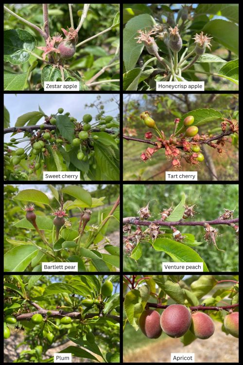
This week’s weather is mixed with some warm and cool days and rain in the forecast for the Grand Rapids and west central Michigan regions. Fruitlets are growing steadily. Now, sweet cherry, tart cherry, peaches and apricot are out of the shuck. Apples and pears are at fruit set, and apples are approaching traditional thinning time at many orchards (Figure 1).
This week, average temperatures will be slightly warmer than last week but still cooler than normal for this time of year. Daytime highs will be in the mid-60s to low 70s, and lows will be in the 40s or low 50s according to the Hart Enviroweather station. Similar temperatures are forecasted for the Sparta Enviroweather station, and temperatures could approach 80s later in the week in early June.
Cool temperatures have kept phenological moving slowly and steadily and insect activity has been limited so far this season. Based on the Hart Enviroweather station for May 26, current degree day (DD) accumulation is 587 DD42 and 275 DD50. For the Sparta Enviroweather station, current DD accumulation is 736 DD42 and 378 DD50.
Current degree day accumulation is now lower than the five-year average for the west central region (Table 1) and for Grand Rapids (Table 2) according to the Enviroweather stations.
For the next few days, it will be cooler with a chance of rain on Wednesday, May 28, and possibly Thursday and Friday across the regions.
Get the full weather update from Jeff Andresen, MSU climatologist.
Table 1. West central region: Current and five-year average DD summary from Jan. 1- May 26. Numerical integration was used for degree day calculations.
|
Station |
2025 DD Base 42 F |
5-yr Avg DD Base 42 F |
2025 DD Base 50 F |
5-yr Avg DD Base 50 F |
|
Benona/Shelby |
529 |
623 |
240 |
312 |
|
Elbridge/Hart |
621 |
677 |
310 |
354 |
|
Fremont |
676 |
729 |
347 |
385 |
|
Grant |
735 |
757 |
384 |
405 |
|
Hart |
587 |
664 |
275 |
340 |
|
Ludington |
561 |
636 |
256 |
326 |
|
Mears |
576 |
662 |
267 |
340 |
|
New Era |
596 |
679 |
281 |
347 |
|
Shelby-East |
618 |
678 |
298 |
352 |
Table 2. Grand Rapids region: Current and five-year average DD summary from Jan. 1- May 26. Numerical integration was used for degree day calculations.
|
Station |
2025 DD Base 42 F |
5-yr Avg DD Base 42 F |
2025 DD Base 50 F |
5-yr Avg DD Base 50 F |
|
Sparta |
736 |
761 |
378 |
404 |
|
Alpine Twp/ Comstock Park |
755 |
783 |
388 |
417 |
|
Sparta-North |
727 |
767 |
368 |
405 |
|
Conklin/Wright |
737 |
782 |
373 |
415 |
|
Kent City |
707 |
756 |
355 |
401 |
|
Standale/Walker |
792 |
831 |
416 |
453 |
|
Belding |
728 |
767 |
371 |
413 |
|
Clarksville |
776 |
793 |
397 |
425 |
Weather data was gathered from MSU Enviroweather.
Rain during storms last week enhanced soil moisture across west Michigan. For the Hart Enviroweather station, precipitation from May 20-22 was 2.03 inches. For the Sparta Enviroweather station, precipitation totaled 0.90 inches during that time.
For the Hart Enviroweather station on May 26, maximum soil temperature at 2 inches depth was 70.4 degrees Fahrenheit, and at 4 inches depth, maximum temperature was 66.1 F. Soil temperatures are gradually warming, and optimal soil temperatures for roots is about 64-77 F. Maximum soil moisture at 4 inches is 11.6% and at 20 inches it is 9.7%. For the Sparta Enviroweather station on May 26, maximum soil temperature at 2 inches depth was 70.5 F, and at 4 inches depth, maximum temperature was 65.8 F. Maximum soil moisture at 0-12 inches is 51.5% and at 12-24 inches it is 55.3%, similar to last week.
More information and reports on normal weather conditions and departures from normal can be found on the NOAA Climate Prediction Center website, NOAA U.S. Climate Normals website, NOAA Climate Normals Quick Access Page (which may be searched by region) and Midwest Regional Climate Center website.
Crop update
Apple varieties in Oceana County range from petal near the lake shore to 8-10 millimeters (mm) for early varieties. Zestar have an average fruitlet size of 11.5 mm, and average Idared fruitlet size is 11 mm. Later varieties such as Gala and Honeycrisp are at fruit set with king fruit at 7.5 and 8.5 mm respectively. Average fruitlet size for Minneiska is 9.6 mm. There is a wider range of phenological stages on trees this season, which is likely due to changes in temperature with mixed conditions of warm then cool temperatures. This may be helpful for thinning as king fruit will be more competitive than the lateral fruit, and laterals will be more affected by chemical thinners.
For fruit thinning, conditions will be generally cool and cloudy this week; however, there will be some good windows for fruit thinning with warmer days in the forecast later this week. The Cornell Apple Carbohydrate Thinning Model shows that Hart and Sparta have a carbohydrate surplus as of May 26, and the thinning efficacy will be mild. If you look at the carbohydrate balance graph, the surplus has gone down and is slightly above the balance for six-day average threshold of 0. On May 27, the calculated six-day average is 7.85 for Hart and 2.73 for Sparta. This timing is important physiologically as trees are using up their carbohydrate reserves and new leaf tissue has not started supplying all the carbohydrates needed for developing fruitlets.
This is a “sweet spot” for thinning time when fruitlets are most sensitive to chemical thinners. After this timing, shoots that are about 12 inches long will begin supplying carbohydrates to the tree, which generally occurs when fruitlets are about 15 mm. This new supply of carbohydrates from actively growing shoots makes fruitlets less responsive to thinners.
According to the Apple Thinning Guide from Michigan State University Extension, the thinning sensitivity is low at petal fall, greatest at 10 mm, and then quickly becomes insensitive as the 25 mm stage is approached. The thinning response is also driven by the weather at the time of thinning. Hot cloudy conditions at any of these stages will promote thinning, and under cool and sunny weather, thinners will be less effective. Watch the weather forecast this week to apply thinners at the start of a warming trend as the weather three to four days after the thinner applications is critical to thinning efficacy.
There is variation in fruit set this year by block and variety. For blocks with heavier fruit set, higher rates of thinner applications may be needed because there is a lot of new leaf growth currently and temperatures have been cool. Oil can also be added to enhance the thinning response if needed; however, if nighttime temperatures are around freezing or if captan has been used recently for disease management, oil should not be used because it can cause phototoxicity and tissue damage.
There have been some reports that varieties, such Fuji and Honeycrisp, have lower fruit set this year, but that is dependent on orchard block and cropping history. Other varieties, such as Gala and Idared, have adequate fruit set. Scout orchards block by block to determine if a chemical thinner is needed. It is important to scout orchards on foot this season. There is more foliage now than is typically seen at thinning time, and it is difficult to see fruitlets that are there without close inspection. Also, look throughout the canopy as fruit set is often higher in the top of the tree compared to the bottom.
As a reminder, measure fruit daily or every few days to determine if fruit are continuing to grow or if they stop growing. Use the fruit growth rate model to determine fruit set and efficacy of thinner applications. Fruit that continue to grow steadily will persist, and fruitlets that are growing at a rate of 50% or less than the fastest growing fruit will abscise.
Learn more about the fruit growth rate model.
Sweet cherry are out of the shuck and growing steadily with good fruit set for varieties such as Black Pearl, Ebony Pearl and Regina in some orchards. The largest fruit are 15 mm on average. Tart cherry are out of the shuck in Oceana and Mason counties. At the West Central Michigan Research and Extension Center, average fruitlet size was 9 mm.
Peaches are at shuck split for some varieties or out of the shuck depending on the variety. Venture peach at the West Central Michigan Research and Extension Center are at shuck split with average fruitlet size of 6.3 mm. Glenglo was out of the shuck, and average fruitlet size was 8.6 mm.
Apricots are growing steadily, and average fruit size is 25.4 mm in Oceana County.
Plums are at early fruit set or out of the shuck for European and Japanese varieties. Stanley plums measured at 7 mm on average.
Pear fruitlets are growing and starting to separate in clusters with actively growing fruit and fruit that will naturally fall. Average fruitlet size was 10.1 mm for Bartlett pear at the West Central Michigan Research and Extension Center.
Pest and disease update
Diseases
Cool weather over the last week led to little insect activity and low trap counts in Oceana County. Warmer weather this week will enhance insect activity and flight into the orchard for pests like plum curculio and oriental fruit moth. There will be some risk for apple scab and cherry leaf spot but cool temperatures will slow spore germination and fungal growth during rain events on May 28 and 29. Longer wetting periods are needed for apple scab and cherry leaf spot infection with cool temperatures.
Insect pests
In Oceana County, no green fruitworm were caught this week. Few redbanded leafroller (two adults per trap) were trapped this week. Oriental fruit moth was trapped with an average of 1.5 moths per trap which is much lower than the last few weeks. Monitor orchard blocks closely to set block specific biofix dates where needed.
American plum borer was not trapped this week at the West Central Michigan Research and Extension Center. Lesser peach tree borer was trapped for the second time with an average of one borer per trap. Plum curculio have been trapped throughout the state, and with warmer temperatures forecasted for later this week, they will be likely be laying eggs and feeding in orchards.
No codling moth or lesser apple worm were trapped this week in Oceana County with the MSU trapline in west central Michigan.
Codling moth and oriental fruit moth were trapped again this week in Fennville at Trevor Nichols Research Center and in Sparta. Plum curculio was not trapped this week, which was down from last week (three per trap on May 19).
For more information about regional reports, please visit the Michigan State University Extension website.
This work is supported by the Crop Protection and Pest Management Program [grant no 2024-70006-43569] from the USDA National Institute of Food and Agriculture. Any opinions, findings, conclusions, or recommendations expressed in this publication are those of the author(s) and do not necessarily reflect the view of the U.S. Department of Agriculture.

