When the rain comes
 Print
Print Email
EmailAdd Summary

July 19, 2016
Anna Herzberger is an MSU Center for Systems Integration and Sustainability doctoral student doing research in the Heilongjiang Province in northeastern China. She hails from the farmlands of Virginia, Ill.
My fieldwork in China started off rough.
After the sparkle of the first week – being an honored guest, attending lavish dinners and getting private tours – wore off what remained was me, our research team of five and a project that had some serious American bias hiding within it.
The soil analysis for my project relies on linking the soil sample with an in-depth farmer interview. This provides some serious analytical and explanatory power not often found in research. This is one of the main benefits (and challenges) of doing interdisciplinary research; after all, I hope to explain ecological effects to their respective social (human) causes.
So the plan was that the Chinese part of team (Jing Sun, Yue Dou and Yuxin Tong) would conduct the interviews and collect the information necessary for me to do the soil analysis, then Ciara (a new Ph.D. student in the Liu group) and I would go out collecting soil samples and other relevant data. In the U.S., where I developed this project, one farmer owns one field usually near their house. However, in China, due to the land ownership system, farmers live together in a clump of houses and the fields surround the village. Furthermore, one field is actually made up of lots of small plots belonging to many farmers.
During the first few days of field work the research team would show the farmers a map (that Yue graciously, downloaded and printed off each night) and collect information from the farmers on the locations and size of their plot. For example, “My plot started 200 meters down the field and is 200 meters long and is 8 rows wide, 500 rows from the road”. When I would go to find the plot using these directions, it was literally impossible. Often the plots that were much bigger or smaller than the information provided by the farmer or sometimes the fields were simple not there. This caused confusion and disappoint among our research team, often leaving us standing in the field passing the map back and forth trying to determine the plot location.
After a few truly terrible days, an alternative solution was suggested: we would reduce the sample size of our project to allocate more time to get fewer samples (quality over quantity). We would also ask the farmer to accompany me to the field and show me his plots. This ensured accuracy of that the soil sample was taken from the correct plot. After this change things went more smoothly, the farmers even seemed to enjoy helping me do the sampling.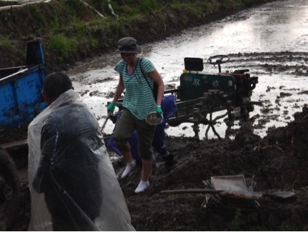
However, my American-agriculture bias was not done plaguing the project. The next major hiccup we experienced was when I, raised in the corn belt, attempted to sample rice. Mind you, I had never actually seen a rice paddy before arriving in China. On an especially rainy day, the research team identified the first rice plot and drove me to it. I, with all the confidence in the world, hopped out of the car and walked directly into the paddy. After all, the protocol stipulates I generate an aggregated soil composite that is representative of the entire field, meaning I needed soil cores from the center of the plot.
The rice paddy-soil is covered in a few feet of water, so I quickly sink in up to my knees, the mud locking around my boots. I attempted to take a few steps, encouraged by cheers from the research team and nearby farmers. But alas it was in vain, I abandon my boots in