Winter injury update to Michigan trees and shrubs
The cold snap on Nov. 11, 2019, could have lasting impacts on trees and shrubs.
Winter is always a tough season for trees in shrubs in Michigan. The winter of 2019-2020 is already off to rough start in some parts of the state as many locations in the eastern and southern parts set record cold temperatures during the week of Veterans Day, Nov. 11, 2019. This cold snap was part of a widespread outbreak of cold weather that broke over 400 daily low temperature records in the eastern U.S. On the morning of Nov. 12, many Michigan State University Enviroweather stations in southern and eastern Michigan had low temperatures in the single digits and some approached 0 degrees Fahrenheit or below. The Hudson Enviroweather station in southern Michigan recorded minimum temperatures of -3.4 and -3.9 F on Nov. 12 and 13, respectively.
Why is this cold snap an issue?
In discussing cold damage and plants, we have to consider not only the minimum temperature but also when the lows occurred. The temperatures that are likely to cause damage to trees and shrubs decrease as plants become progressively more cold hardy in the fall (acclimation). During this time, plant cells accumulate solutes and undergo other changes that make them better able to withstand extreme cold in January and February. As days get longer and temperatures begin to rise in the spring, these processes are reversed (dehardening) and plants begin to lose cold hardiness (Fig. 1).
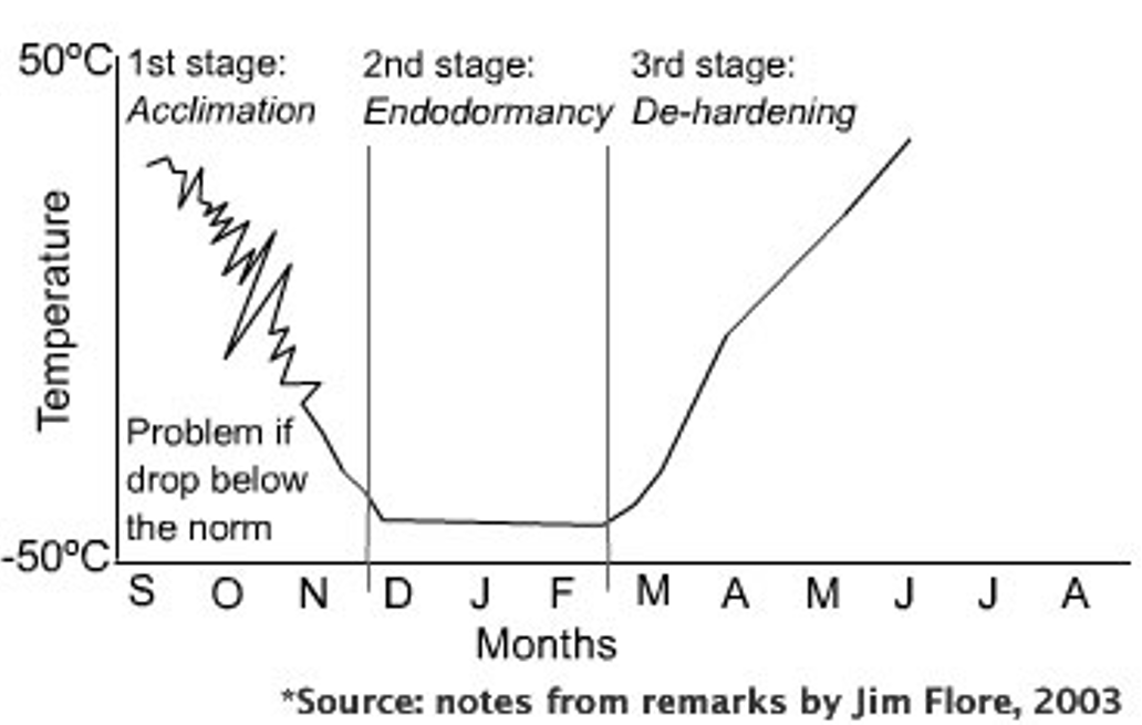
In Michigan, our most common scenario for freezing damage is late winter injury that occurs in late winter/early spring when we often experience rapid warmups that increase dehardening followed by a sudden temperature drop. Occasionally, we can have extreme cold weather in January and February that can result in mid-winter injury as we saw during the Polar Vortex events in early 2013 and 2014. Even less common in Michigan is early winter injury, which occurs when plants are exposed to extreme cold before they have full acclimated in the fall.
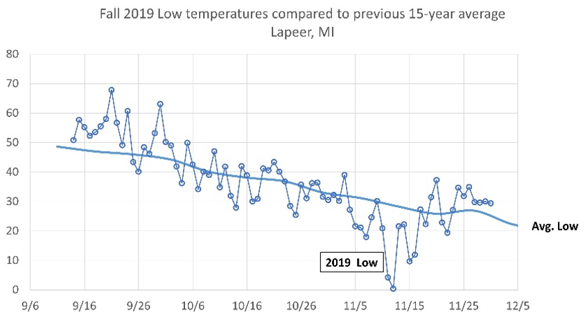
Early winter injury occurs relatively frequently in places like Montana and Colorado, where 30+ degree temperature swings from one day to the next in October and November are considered the norm. In Michigan, the Great Lakes help to moderate early season incursions of Arctic-origin air into the region and we often feel less impacts from these systems. In the case of the 2019 Veterans’ Day cold snap, our temperatures had been tracking right around normal throughout October and into early November and then took a rapid nosedive (Fig. 2). In Lapeer, Michigan, for example, the low on Nov. 9 was 30 F, right at the average. By the morning of Nov. 12, the low was 0.4 F.
What impacts will this cold snap have?
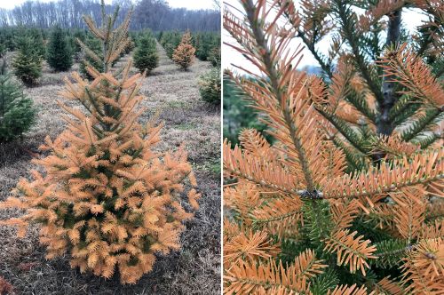
We have already seen impacts of the early cold on some conifers in nursery and Christmas tree plantations. In most cases the damage has been limited to needle browning, but shoot buds still appear to be heathy. This suggests these trees will flush normally in the spring and long-term impacts will be minimal.
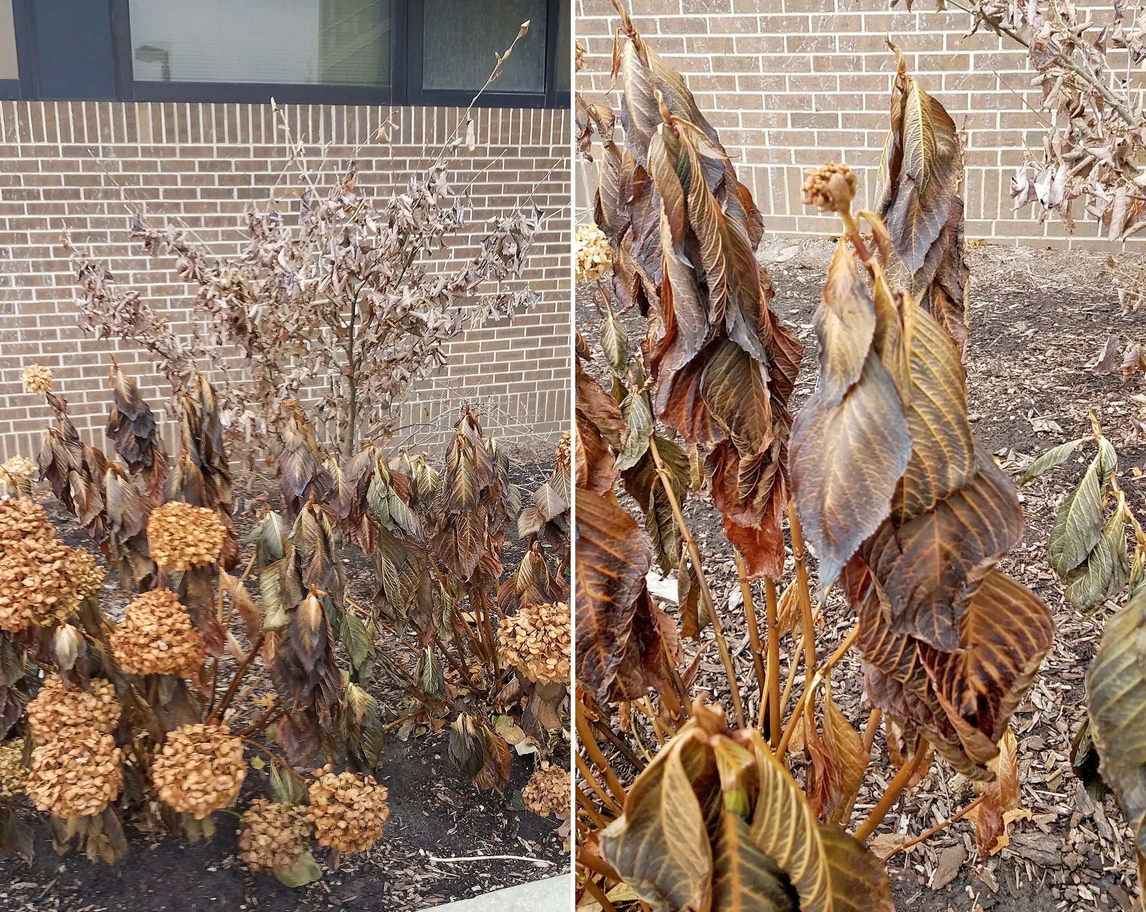
In landscapes, leaves on many deciduous trees and shrubs froze before they had a chance to completely senesce. Oftentimes these leaves have a wilted or water-soaked appearance. Again, the long-term impact will likely be minimal given that trees were about to shed these leaves anyway, though it’s possible buds or shoots may have been damaged on marginally hardy trees or shrubs.
What lies ahead?
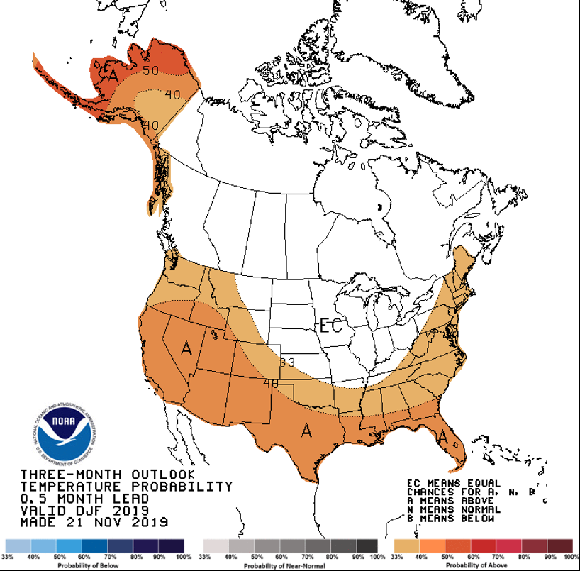
The official start of winter is still a couple weeks away (Dec. 21, 2019), and a lot can—and will—happen between now and spring. Landscape plants are subject to array of stresses over the winter. In addition to extreme cold, drying winds, deicing salt exposure, mammal damage, and ice and snow loads can all impact trees and shrubs over the winter. The current three-month outlook from the National Weather Service Climate Prediction Center indicates near normal mean temperatures throughout the Great Lakes region (Fig. 3). Of course, normal in this region still includes heavy snows, sub-zero lows and high winds. Moreover, severe weather events, which cause the biggest issues for trees and shrubs, are difficult to capture in long-range forecasts. As with most years, the ultimate gauge of winter’s impact on our landscapes will be apparent in April and May.


 Print
Print Email
Email
