Sterling Heights Van Dyke Corridor Plan
DOWNLOADAugust 8, 2025 - Nicolas Ceme-PreFontaine, Allyson Smolarek, Robert Foster, Alexander Hill, Charles Matthews, Evan Willey
 Print
Print Email
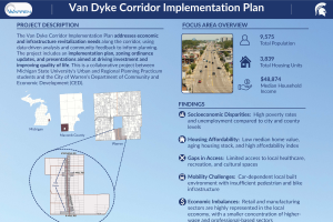
EmailThe Van Dyke Corridor (14 Mile to 18 Mile Roads) in Sterling Heights, Michigan, is a vital commercial and residential artery in one of Metro Detroit's largest suburban communities. As the city continues to grow and evolve, the corridor faces mounting challenges stemming from decades of auto-centric planning. Expansive surface parking lots, disjointed pedestrian networks, limited bicycle and public transit infrastructure, and outdated zoning regulations have all contributed to an environment that discourages non-motorized transportation, limits development potential, and reduces quality of life for residents and visitors alike. Recognizing the strategic importance of the Van Dyke Corridor, the City of Sterling Heights has identified it as a priority for redevelopment. This transformation plan provides a data-driven, community-informed roadmap for converting the corridor into a vibrant, accessible, and economically resilient mixed-use destination.
Currently, the corridor is dominated by low-density, single-use commercial developments. These developments are characterized by deep setbacks, vacant big-box retail stores, and an oversupply of parking that isolates buildings from the street and pedestrians from storefronts. Sidewalks, while present along Van Dyke, are frequently interrupted or too narrow, and connectivity from the corridor to store entrances is often nonexistent. Public transportation access is insufficient, with limited SMART bus stops offering little in terms of rider comfort or visibility. In addition, key economic and housing indicators show that while Sterling Heights remains a strong regional player—boasting over $7.9 billion in Gross Regional Product and a stable housing market—barriers to equitable access and walkability persist. Strategic investments in infrastructure, zoning reform, and placemaking are required to overcome these challenges.
To address these issues, the transformation plan presents a three-tiered strategy: short-term, mid-term, and long-term recommendations. Short-term strategies (0–2 years) focus on low-cost, high-impact improvements such as temporary public spaces, high-visibility crosswalks, and delineated pedestrian paths. These interventions would improve immediate walkability and user experience, especially in underutilized parking areas. Mid-term strategies (2–5 years) propose more permanent infrastructure changes including the construction of ADA-compliant sidewalks connecting Van Dyke to major store entrances, installation of pedestrian-scale lighting, and enhanced streetscape amenities like benches, bike racks, and planters.
These elements support long-term pedestrian use and catalyze further development. Long-term recommendations (5–10 years) aim to reconfigure land use patterns by incentivizing infill development, reducing parking minimums, and promoting mixed-use redevelopment. By repurposing excess parking and updating restrictive deed covenants, the city can attract investment and increase corridor density.
Each recommendation is grounded in national best practices and successful precedents, such as the Southfield City Centre Trail Project, which improved pedestrian and bicycle access in a similarly auto-dominated suburban environment. Similarly, placemaking strategies modeled after the Minneapolis Tactical Urbanism Kit demonstrate how low-cost interventions can evolve into permanent transformations. The plan also calls for expanding the city's Corridor Improvement Authority boundary and renewing its TIF district to fund improvements equitably across the entire corridor. Education, incentive programs, and grant funding—like Milwaukee’s “Depave” green space initiative— are recommended to encourage private property owners to redevelop oversized parking lots into usable public or green space.
Overall, this transformation plan is more than a design proposal; it is a strategic framework for creating a more livable, accessible, and economically vibrant Van Dyke Corridor. By integrating multimodal transportation planning, zoning reform, economic development strategies, and inclusive design, Sterling Heights can establish itself as a forward-thinking city committed to sustainability, equity, and placemaking. Through thoughtful implementation of this plan, the Van Dyke Corridor can become a model for suburban revitalization, connecting people to places and catalyzing growth for decades to come.