The City of Pontiac West Huron Corridor Study Executive Summary and Poster
DOWNLOADAugust 15, 2022 - Michael Carney, Owen Porter, Dan Seguin, Patrick Kayser, Emma Gilbert, Joey Emery, Quinton Hay, Michael Maksym
 Print
Print Email
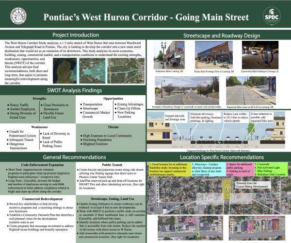
EmailThe West Huron Corridor Study analyzes a 1.5-mile stretch of the corridor between Woodward Avenue and Telegraph Road in Pontiac, Michigan (referred to later as the “study area”). Pontiac’s goal is to establish the corridor as a destination location for commercial businesses as an extension west of its downtown. The study was initiated to gain an understanding of the corridor’s current conditions including socio-economic, building, zoning, commercial market, and transportation conditions. This data is utilized to inform a thorough assessment of the corridor and delineate its strengths, weaknesses, opportunities, and threats (SWOT). The elements of the SWOT analysis are then used to advise final recommendations, both short- and long-term, that aspire to elicit growth and meaningful redevelopment along the corridor. These recommendations serve as a roadmap for the city to refer to when considering ways to plan for and implement corridor improvements and economic growth.
An analysis of the socio-economic profile shows that, between 2010 and 2020, the study area experienced an 8.5 percent decrease in population, although the City of Pontiac and Oakland County both experienced marginal increases. Furthermore, the wholesale trade industry experienced the largest decline in employment (59.3 percent) throughout the study area between 2010 and 2019. Part of this decline may be attributed to General Motors decreasing its presence within Pontiac.
Zoning and land use data pertaining to the corridor show a mix of commercial, residential, and mixed-use zoning along the corridor. Most of the corridor is comprised of C-0 Office Businesses, C-1 Local Businesses, and R-1 One Family Dwellings. These zoning codes are mixed in their location along the corridor, giving the corridor many uses throughout the one-and-a-half-mile area. Pontiac’s zoning ordinance allows for mixed-use but requires ground-level commercial space for any mixed-use building and second-floor residential space, which allows for future businesses to locate along the street level in hopes of capturing pedestrian traffic as corridor redevelopment strategies are implemented. A lack of easily accessible parking is observed along the corridor, complicating automobile access to businesses lining the corridor.
The commercial market analysis identifies the business types observed throughout the corridor, breaking down the study area into radii of one, three, and five miles. Through these radii, a few anchor businesses are identified, including the Pontiac General Hospital, which is located near the center of the corridor, the Oakland County Circuit Court (public administration), and Lee Industries. These employers make up most of the workforce, particularly within a one-mile radius. The leakage and surplus study show that the corridor is well positioned with a diversity of different stores. Still, a significant issue is the large umbrella in which retail stores fall under. Many of the retail stores along the corridor sell similar goods, lacking diversity, and there is no grocery store or casual dining along the corridor. These two businesses could be crucial to economic development along the corridor. The corridor does not specialize in one specific business, which is a strength, but adding more retail diversity to the corridor, particularly anchor stores or niche small, local businesses could help drive more traffic to the corridor.
The transportation analysis focuses on streetscape improvements and a right-of-way redesign strategy to tackle dangerous issues that arise relating to cars, pedestrians, and bicyclists. Most people who work or live within the study area own a car and drive to their place of employment, driving the high traffic volumes that the corridor experiences, but also playing a part in the high number of automobile crashes along the corridor. The crash analysis identifies concentrations of bike and pedestrian crashes that can inform the location of future crosswalks.
The practicum team’s recommendations focus on applying the data analyzed in this report and allocating resources to issues the team identifies are most in need of improvement and that could reinforce the economic prosperity of the corridor. Recommendations are separated into short- and long-term to create the best roadmap for the city to consider and implement. Short-term recommendations are items that could be accomplished within three years and would offer significant improvement at a lower cost and time investment. The long-term recommendations focus on improvements that could be implemented between three and five and include items that are either more costly or time-consuming to implement, or both.
The recommendations are broken down into different themes. These themes include streetscape improvement strategy, zoning recommendations, land use recommendations, commercial redevelopment opportunities, public transit, right-of-way redesign strategies, and code enforcement expansion.
The streetscape improvement strategy, public transit, and right-of-way design strategies are grounded in secondary data that was gathered through MDOT (Michigan Dept of Transportation) and SEMCOG (Southeast Michigan Council of Governments). This data provides helpful insights into analyzing the corridor’s traffic and crash patterns. Allocating funding to the completion of a feasibility study to consider the potential for a roadway adjustment along the corridor could provide insight on whether road space saved from the removal of a third lane could aid in the implementation of bicycle and pedestrian infrastructure along the corridor, such as buffered bike lanes and median protected crosswalks.
The commercial redevelopment opportunities are developed in accordance with the commercial market study. Conducting a build-out and feasibility analysis to identify potential in-fill development and retrofitting along the corridor is a great investment opportunity. This study would also identify how vacant or underutilized spaces along the corridor may be adapted into new commercial developments that fill the leakages identified in the commercial market analysis, such as casual dining or a grocery store. Establishing a community outreach plan to engage residents and stakeholders in the process of prioritizing new commercial developments would help Pontiac understand how to incentivize new development that meets their community’s needs. Engaging the community would also help build a shared vision for the future of the corridor. Creating a shared vision helps people feel a sense of ownership and pride in the changes they see being implemented in their community.
The code enforcement expansion recommendations were inspired by interviews with city employees. These recommendations include expanding the city’s code enforcement budget to hire additional officers to monitor and enforce compliance related to blight and clean-up efforts more closely. Hiring additional enforcement officers would ensure a pointed focus on code enforcement in each of the seven districts in the city, including the corridor.
Overall, the practicum team team’s data analysis illuminated the current strengths, weaknesses, opportunities, and threats of the corridor. The recommendations presented in this report reflect actions the City of Pontiac can adopt to address some of its weaknesses and threats and capitalize upon its strengths and opportunities. In addressing opportunities for market growth, improvements to multimodal transit accessibility, implementing additional safety amenities, and leveraging community engagement to create a coordinated vision for the corridor, the recommendations provide a roadmap for future beautification and redevelopment efforts along the corridor. In implementing these recommendations, the City of Pontiac will move the needle closer to achieving its goal of transitioning the West Huron corridor into a Main Street style destination.