Rainfall “feast or famine”
Recent rainfall patterns across Michigan have been highly variable, leading to flooding in some areas while others remain unfavorably dry. Outlooks suggest more weather changes may be just around the corner.
A frequent comment I hear from readers over time is that the usefulness of long term climate normals in describing Great Lakes region weather is limited because we seem to experience everything but the normals. Indeed, the variability of day-to-day weather around the normals can be very large. A perfect case in point would be the accumulation of precipitation so far this growing season.
The 2011 growing season began with much wetter than normal weather through much of April, May and early June (some areas of the state recorded more than 200 percent of normal rainfall), which led to persistent and significant delays in spring planting and other fieldwork. Beginning in mid-June, a large ridge of high pressure developed across central and southern sections of the Lower 48 states and brought excessive heat to large sections of the country including Michigan. While much of the northern Great Plains and Upper Midwest experienced frequent periods of shower and thunderstorms and above normal rainfall along the northern periphery of the ridge, the majority of Michigan and the eastern Great Lakes region remained much drier than normal through late July, with some areas receiving less than 25 percent of normal rainfall.
Finally, the passage of a cool front and upper air disturbance through a hot, very humid air mass led to heavy rainfall across southern sections of the state on July 27-29 (mostly in two separate, overnight events on the 27th and 28th). Some areas recorded almost 10 inches of rainfall in a 36-hour period, resulting in localized flooding. That intensity of rainfall is very uncommon in Michigan (or anywhere else for that matter outside of land-falling hurricanes and tropical cyclones). For some historical perspective, a one in 100-year, 24-hour rainfall event in this part of the state is approximately 5 inches.
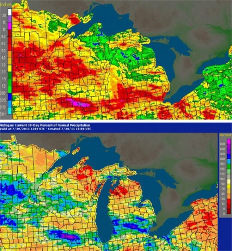
A map of 30-day radar-estimated rainfall totals for June 30 through July 29 across the region is given in Photo 1 (top), and illustrates the wide variability in rainfall totals and resulting soil moisture conditions across the state and region. Heaviest rainfall with the two events on July 27-29 fell in an area from Ottawa and Allegan counties southeastward towards the Detroit metro area (following the general movement of the thunderstorms responsible for the rain). Meanwhile, a large portion of northern Michigan from the western Upper Peninsula through northern Lower Michigan recorded less than 0.50 inches, for a range of more than 9.50 inches during the period. As a result, soils across the state currently range from waterlogged or flooded to unfavorably dry.

Click on image to enlarge.
Photo 1. Radar-estimated precipitation totals (top) and percent of normal precipitation
(bottom) across Michigan and the Great Lakes region, June 30-July 29, 2011. Figures
courtesy of NOAA National Weather Service, Advanced Hydrologic Prediction Center, Silver Springs, MD.
Looking ahead
While the upper air ridging pattern mentioned above is likely to continue its influence across the central USA and Great Lakes region with above normal temperatures for much of the upcoming week, there are growing signs that a major pattern change is in store for the region within the next one to two weeks. In the short term, a cool front is forecast to pass through the state Tuesday (August 2), which should bring a good chance for showers and thunderstorms, with numerous 0.25- to 0.50-inch totals. For a change, best chances for rainfall will be across northern areas of the state missed by earlier rainfall.
All rainfall will come to an end following the passage of the front by late Tuesday, with fair and dry weather expected Wednesday and Thursday. A second frontal boundary will pass through the region by late Friday into Saturday with the next chance for rainfall. Temperatures during the short term will remain at much above normal levels, reaching the upper 80s north to low 90s south on Tuesday. Slightly cooler temperatures are likely following the frontal passage, with highs from near 80 north to the mid- and upper 80s south Wednesday through Friday. Low temperatures will generally range from the mid-50s to near 60 north to the upper 60s south.
Recent medium range forecast guidance has been consistent in suggesting at least a temporary upper air pattern change across North America during the next one to two weeks, with the gradual weakening and westward retrogression of the massive upper air ridge while a troughing feature develops across the eastern USA. That change would ultimately bring northwesterly flow and significantly cooler weather back to the Great Lakes region. NOAA Climate Prediction Center 6-10 and 8-14 day outlooks (covering August 6-10 and 8-14) both call for precipitation totals to range from near normal levels north to above normal levels south. Near normal mean temperatures are forecast during the 6-10 day period while a below normal levels are expected across all but northwestern sections of the state during the 8-14 day time frame.
Further ahead, the latest Climate Prediction Center 30-day outlook for August is vague, calling for near equal odds of below-, near-, and above-normal mean temperatures and precipitation totals for Michigan and the entire Great Lakes region. However, for the three-month August through October time frame, the outlook calls for the increased likelihood of above normal mean temperatures. Precipitation totals during this time frame are forecast to remain in the equal odds category statewide.
Dr. Andresen's work is funded in part by MSU's AgBioResearch.


 Print
Print Email
Email


