The GLANSIS Map Explorer: Tracking Great Lakes Invaders
 Print
Print Email
EmailThe Great Lakes Aquatic Nonindigenous Species Information System (GLANSIS) is a user-friendly information portal designed specifically for the Great Lakes basin, using verified reports to document the spread of non-native species.
Keeping track of nonindigenous species in the Great Lakes is an important part of protecting the region from aquatic invaders. While a number of different databases exist to keep tabs on invasive species throughout North America, the Great Lakes Aquatic Nonindigenous Species Information System (GLANSIS) is a user-friendly information portal designed specifically for the Great Lakes basin, using verified reports to document the spread of non-native species.
Interactive mapping
The new GLANSIS Map Explorer provides an interactive mapping feature that retrieves specimen records and their associated geographical coordinates for species in the GLANSIS database, displaying the results on a map of the Great Lakes region. The GLANSIS Map Explorer was developed by Joeseph Smith from the Cooperative Institute for Great Lakes Research, in partnership with National Oceanic and Atmospheric Administration-Great Lakes Envrionmental Research Laboratory, the U.S. Geological Survey, Michigan Sea Grant and the University of Michigan’s School of Environment and Sustainability to meet an identified need for better access to the regional geo-referenced data contained within GLANSIS.
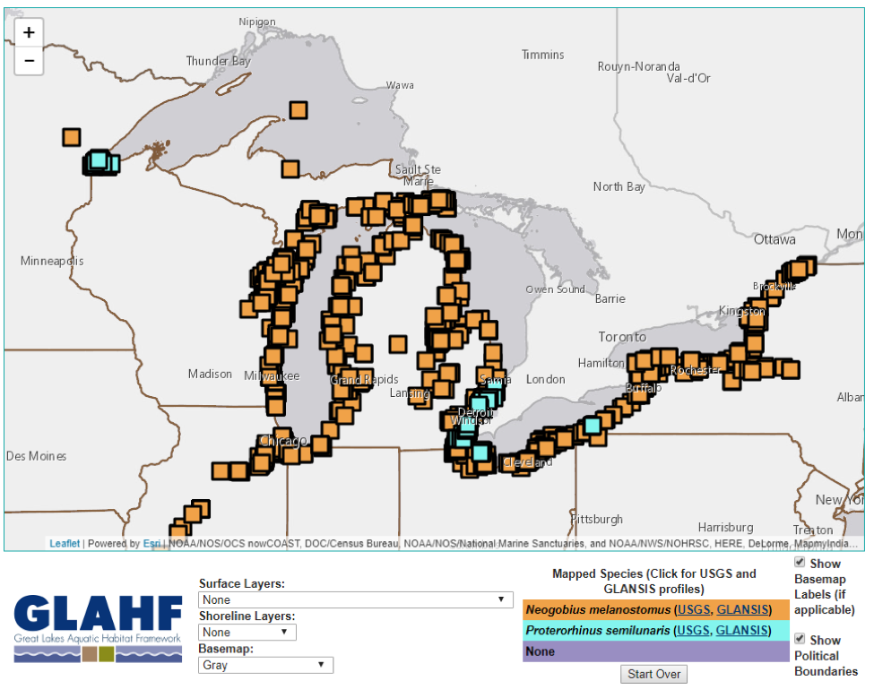
Using the Map Explorer tool, users can display reports of up to three different species at a time (such as the round goby Neogobius melanostomus and tubenose goby Proterorhinus semilunaris, as displayed above). Alternatively, a single species can be mapped at three different points in time in order to observe the spread of round goby sightings, for instance, from 1950-1960, 1970-1980, and 1990 to the present to see how their range has expanded. A series of still map images can also easily be strung together in powerpoint or another program to create time-series animations. Data can be narrowed geographically to specific watersheds, and users can zero in on particular sites more closely.
‘Hot button’ species
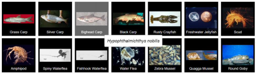
A selection of “hot button” species is also provided for some of the most notorious Great Lakes invaders, such as the bighead carp, so users can map information with a single click. These searches all provide a link to profile pages for the species in question, so users can click through to learn more about their identification, ecology, and management.
Other map layers
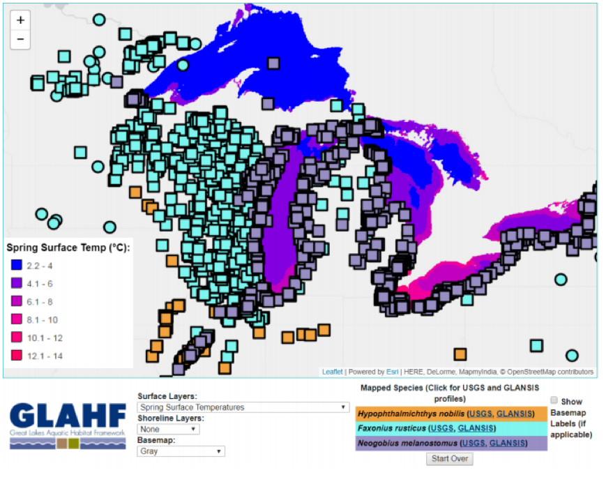
The Map Explorer also provides other map layers from the Great Lakes Aquatic Habitat Framework (GLAHF) such as lake depth or surface water temperature so users can compare these factors with species distribution patterns. These map layers allow users to compare sightings of a particular species with any number of environmental variables, like ice duration, upwelling, and temperature, to investigate how these factors might influence an organism’s establishment or spread. Layers are also available for ‘habitat suitability maps’ for a small selection of potential invaders drawn from cutting-edge NOAA-funded research.
Users can also download the data presented in the Map Explorer for use in their own projects with their preferred spreadsheet or GIS program. Researchers, environmental managers, students, and other stakeholders can all utilize this free online tool to learn more about particular species and their patterns of invasion throughout the Great Lakes region. References for all the data in a particular selected map can also be easily downloaded through the interface.
To learn more about the GLANSIS Map Explorer, read the recent paper published in Management of Biological Invasions, and use the GLANSIS website to try out this tool for yourself.
Michigan Sea Grant helps to foster economic growth and protect Michigan’s coastal, Great Lakes resources through education, research and outreach. A collaborative effort of the University of Michigan and Michigan State University and its MSU Extension, Michigan Sea Grant is part of the NOAA-National Sea Grant network of 33 university-based programs.
GLANSIS is a NOAA-led clearinghouse of ANS information for the Great Lakes region and a Great Lakes regional node of the USGS Nonindigenous Aquatic Species (NAS) database. This article was prepared by Michigan Sea Grant Extension under award NA17OAR4320152 from the National Oceanic and Atmospheric Administration, U.S. Department of Commerce through the Regents of the University of Michigan. The statements, findings, conclusions, and recommendations are those of the author(s) and do not necessarily reflect the views of the National Oceanic and Atmospheric Administration, the Department of Commerce, or the Regents of the University of Michigan. This project was also supported by the Great Lakes Restoration Initiative.