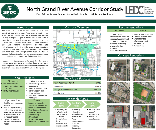
North Grand River Avenue Corridor Study Executive Summary and Poster
DOWNLOADJune 14, 2023 - Dan Fallon, James Maher, Kade Peck, Joe Pezzotti, Mitch Robinson
 Print
Print Email
EmailThe Spring 2023 practicum report focuses on the North Grand River Avenue Corridor, a 3.3-mile-long stretch of roadway from Waverly Road to East Street in Ingham County, Michigan. This report covers a socio-economic profile analysis, zoning, and land use assessment, mobility report, parcel analysis and best use scenarios, community survey, and case study analyses. The purpose of this study is to provide recommendations based on data and research retrieved from various sources that will highlight the highest priority needs of the corridor that will lead to greater economic growth, cohesiveness, and connectivity throughout the study area.
Socio-economic data presented in this report was used to identify community characteristics within seven (7) census tracts to create a study area profile comprising area demographics and economic characteristics. The corridor is experiencing a growth in population with the predominant ages ranging from 20 to 24. Housing trends show an increase in new housing unit construction and a rise in median home value. Residents along the corridor are mainly employed within the education and health care sectors and are seeing a rise in employment and household income from 2010 to 2021. There are also opportunities for economic growth within the arts and entertainment, education, construction, and food services sectors.
Zoning and land use within the study area, supplemented with numerous site visits within the corridor were used to create a zoning and land use assessment highlighting potential land uses for target parcels outlined in this report. The predominant land uses along the North Grand River Avenue Corridor include single-family housing and industrial developments such as warehousing. Future land use trends show the desire for more light industrial development and continued use of low-density residential neighborhoods. Vacant space is designated future open natural space. Paired with existing open space and the Lansing River Trail, opportunities are present to balance nature and greenery with existing industrial uses.
Roadway conditions measurements and concept roadway design is featured in the mobility section. Key locations along the corridor that need attention and improvement are identified. Many roads within the corridor are in poor condition and require repair. The lack of crosswalks along Grand River Avenue also poses a safety threat to drivers and pedestrians, as the latter may resort to jaywalking to cross the four-lane street. There is little to no screening used to provide protection between the road and sidewalks, which may further deter pedestrian travel.
Three vacant parcels located along the corridor were identified for further research. Best-use scenarios identified include new lodging facilities to cater to airport travelers, a community center where local residents can engage with each other, childcare facilities, and new dining options.
A strengths, weaknesses, opportunities, and threats (SWOT) analysis was performed to summarize key areas of interest within the corridor that can provide unique opportunities for growth, as well as identify areas of concern that threaten the wellbeing of residents and businesses. Due to the City of Lansing being the state capital, many residents are employed by the state government and can serve as a catalyst for future development. The Capital Region International Airport is also located along the North Grand River Avenue Corridor, which provides a unique opportunity for economic growth, as it is one of the few airports in Michigan that service international flights and can accommodate high volumes of commercial shipping and receiving. Current threats to the corridor include lack of direct connectivity to Michigan State University and its large student population. The Capital Region Airport also serves as visitors’ first impression of the City of Lansing and the corridor which currently lacks visual appeal which may serve as a deterrent for extended visits.
A community survey was distributed to key stakeholders within the study area to better identify what assets could potentially be introduced that would provide positive social and economic impacts. Many respondents voiced desires for increased dining options within the corridor, infrastructure updates such as additional crosswalks, and an increased focus on community engagement events. Respondents also identified a need for more exterior lighting along the corridor to provide a greater sense of security and pedestrian safety.
This report contains two case studies of similar corridors to highlight successful strategies and methods. Public outreach and community engagement events were often used throughout the case studies to gather public opinion. Another focus was the protection of natural resources and open spaces. The North Grand River Avenue Corridor has many parks and areas used by residents, which presents the goal of preserving these natural spaces. An Environmental Impact Statement (EIS) is a potential method to plan further and ensure natural space continuation.
Recommendations provided within this report are separated into two categories, procedural and physical. Procedural recommendations involve planning processes and strategies that can enhance community engagement and policy implementation, while physical recommendations include tangible changes to the environment of the area including infrastructure updates and beautification changes. Best use cases for the three parcels include a community engagement center, a farmers’ market along with food truck stands and a community garden, and additional dining options and childcare facilities.