Making the most of online water temperature and current data for the 2013 fishing season
 Print
Print Email
EmailSalmon and trout in Lake Michigan often relate to specific water temperatures or edges where warm and cold water currents meet. Savvy anglers have been using websites to plan trips and find fish for years, and online resources keep improving.
Finding fish in Lake Michigan may not seem to have much in common with finding fish in inland lakes, but most predatory fish relate to edges. While bass might relate to drop-offs or weed edges, salmon and trout in Lake Michigan, more often, relate to temperature and current breaks. Depth contours and weed edges can provide reliable fishing throughout the year in smaller lakes, but Lake Michigan is constantly changing. Fortunately, big lake anglers have a variety of online tools available that can help cut down on the time required to find productive water and put more fish in the boat.
The Great Lakes CoastWatch site provides surface temperature charts developed from satellite data. Charts are updated several times a day depending on cloud cover, 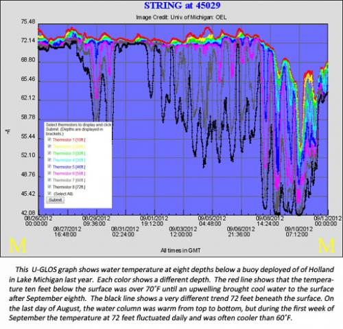 which interferes with the satellites’ ability to sense water temperature. Lakewide, regional, and port views are available in CoastWatch. Over the past two years, upgrades to the port views were piloted. A drop-down menu was added to the Ludington port view, giving users the option to view currents, wave heights, wind velocities, and wave and wind forecasts in addition to surface temperatures. Some of these options may be available for all port views for the 2013 season.
Unlike the surface temperature charts available from CoastWatch, the wave, wind, and current charts are produced using computer models with a variety of real-time data inputs. For this reason, charts like these are said to include “forecasts” or “nowcasts” as opposed to actual conditions. Nowcast and forecast charts are also available and updated four times daily on the NOAA Great Lakes Environmental Research Laboratory’s Great Lakes Coastal Forecasting System (GLCFS) website. The GLCFS site includes surface temperature nowcasts that are different from CoastWatch temperature charts. Although GLCFS surface temperature charts are lower resolution and not based strictly on real-time observations, they have the advantage of being updated regardless of cloud cover.
Temperature transect nowcasts are also available from GLCFS. The transects give projected water temperatures throughout the water column at four cross-sections of Lake Michigan. By late summer, the lake is often stratified, meaning that a warm layer of water (the epilimnion) stretches across the entire lake. Sometimes, strong winds and currents push warm water offshore and create upwellings of cold water in certain areas, but the upwelling of cold water does not always reach the surface and show up on CoastWatch.
The transects can help anglers find minor upwellings, but an even better tool for locating horizontal temperature breaks is real-time data from thermistor strings. Thermistor strings measure temperature at multiple depths below buoys deployed in a few locations in Lake Michigan. Temperature readings and other buoy data are available on the Upper Great Lakes Observing System (U-GLOS) website, which will migrate to www.uglos.mtu.edu by the beginning of the 2013 season. In addition to the latest temperature readings, U-GLOS users can view graphs of temperature profiles for the past several months. This provides valuable insight when paired with angler observations of baitfish, wind conditions, and catch rates.