


West central Michigan tree fruit update – May 20, 2025
 Print
Print Email
EmailTart cherry is at petal fall, and early sweet cherry varieties are at shuck split. Apple varieties are at petal fall or early fruit set.
Weather update
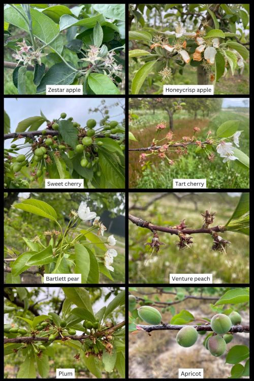
This week’s weather is strikingly different from last week and much cooler in the Grand Rapids, Michigan, and west central regions. Phenological stages moved quickly last week, and trees were in bloom across the region. Now, sweet cherry, tart cherry, peaches and apricot are at petal fall or early shuck split. Apples and pears are in various stages of late bloom, petal fall and early fruit set (Figure 1).
This week, temperatures have cooled compared to last week. Daytime highs have been in the low 60s and 50s the past few days with nighttime temperatures in the 40s. Cool temperatures will slow phenological changes and insect activity this week. Based on the Hart Enviroweather station for May 19, current degree day (DD) accumulation is 538 DD42 and 261 DD50. For the Sparta Enviroweather station, current DD accumulation is 678 DD42 and 356 DD50.
Degree day accumulation is variable compared to the five-year average for the west central region (Table 1) with some sites being ahead, similar or behind the five-year average. The Grand Rapids region is slightly ahead of the five-year average (Table 2) according to the Enviroweather stations.
For the next few days, it will be cool, cloudy, windy and rainy across the region. In Hart and Sparta, temperatures are forecasted to have highs in the 60s and lows in the 40s with a slight warmup early next week. Chances of rain and thunderstorms are predicted this week, especially Tuesday (May 20) through Thursday. This is a cool season weather system with steady and soaking rains in the forecast. Temperatures are unseasonably cool for this time of year and are predicted to remain cool through the end of May.
Get the full weather update from Jeff Andresen, MSU climatologist.
Table 1. West central region: Current and five-year average DD summary from Jan. 1- May 19. Numerical integration was used for degree day calculations.
|
Station |
2025 DD Base 42 F |
5-yr Avg DD Base 42 F |
2025 DD Base 50 F |
5-yr Avg DD Base 50 F |
|---|---|---|---|---|
|
Benona/Shelby |
482 |
493 |
227 |
234 |
|
Elbridge/Hart |
572 |
541 |
292 |
268 |
|
Fremont |
622 |
586 |
325 |
293 |
|
Grant |
679 |
615 |
362 |
314 |
|
Hart |
538 |
530 |
261 |
257 |
|
Ludington |
512 |
508 |
240 |
247 |
|
Mears |
530 |
530 |
255 |
258 |
|
New Era |
547 |
539 |
266 |
260 |
|
Shelby-East |
567 |
540 |
282 |
265 |
Table 2. Grand Rapids Region: Current and five-year average DD summary from Jan. 1- May 19. Numerical integration was used for degree day calculations.
|
Station |
2025 DD Base 42 F |
5-yr Avg DD Base 42 F |
2025 DD Base 50 F |
5-yr Avg DD Base 50 F |
|---|---|---|---|---|
|
Sparta |
678 |
618 |
356 |
313 |
|
Alpine Twp/ Comstock Park |
697 |
636 |
366 |
323 |
|
Sparta-North |
671 |
622 |
347 |
312 |
|
Conklin/Wright |
680 |
633 |
351 |
319 |
|
Kent City |
653 |
609 |
335 |
306 |
|
Standale/Walker |
733 |
680 |
392 |
354 |
|
Belding |
673 |
620 |
350 |
317 |
|
Clarksville |
717 |
645 |
374 |
328 |
Weather data was gathered from MSU Enviroweather.
Rain during storms last week enhanced soil moisture across west Michigan. For the Hart Enviroweather station, precipitation from May 13-17 was 1.46 inches. For the Sparta Enviroweather station, precipitation totaled 1.68 inches during that time.
For the Hart Enviroweather station on May 19, maximum soil temperature at 2 inches depth was 64.5 F, and at 4 inches depth, maximum temperature was 62.2 F. Maximum soil moisture at 4 inches is only 11.5% and at 20 inches it is 9%. For the Sparta Enviroweather station on May 19, maximum soil temperature at 2 inches depth was 62.1 F, and at 4 inches depth, maximum temperature was 59.5 F, which is much cooler than last week’s soil temperatures. Maximum soil moisture at 0-12 inches is 50.7% and at 12-24 inches it is 56.3%.
More information and reports on normal weather conditions and departures from normal can be found on the NOAA Climate Prediction Center website, NOAA U.S. Climate Normals website, NOAA Climate Normals Quick Access Page (which may be searched by region) and Midwest Regional Climate Center website.
Crop update
Apple varieties in Oceana County range from petal fall to early fruit set. Early varieties such as Zestar and Idared are at early fruit set with an average fruitlet size of 5.5 millimeters (mm). Later varieties such as Gala and Honeycrisp are at late bloom and early petal fall. There is a wider range of phenological stages on trees this season which is likely due to changes in temperature with mixed conditions of above and below normal temperatures.
For fruit thinning, conditions are cool and cloudy over the next week. The Cornell Apple Carbohydrate Thinning Model shows that Hart has a carbohydrate surplus, and the thinning efficacy will be mild. According to the MSU Apple Thinning Guide, the thinning sensitivity is low at petal fall, greatest at 10 mm, and then quickly becomes insensitive as the 25 mm stage is approached. The thinning response is also driven by the weather at the time of thinning. Hot, cloudy conditions at any of these stages will promote thinning and cold sunny weather will decrease thinning. With cooler temperatures, it may be more effective to wait to thin until temperatures warm up.
Sweet cherries are out of the shuck and early fruit set for some early varieties like Black Pearl and Ebony Pearl. The largest fruit are 11 mm on average. Tart cherry are at petal fall and early fruit set in Oceana and Mason counties with some fruit at 4 mm in size on average.
Peaches are in the shuck or at shuck split depending on the variety. Venture peach at the West Central Michigan Research and Extension Center in the shuck.
Apricots are out of the shuck and growing with average fruit size at 18 mm in Oceana County.
Plums are at petal fall and early fruit set for European and Japanese varieties.
Pear varieties are at petal fall and early fruit set for Bartlett pear at the West Central Michigan Research and Extension Center with an average fruitlet size of 3 mm for fruit that is growing.
Pest and disease update
Diseases: With hot temperatures over the last week, there was a lot of rapid leaf growth and phenological changes; however, the cool temperatures will slow disease and insect activity this week and info next week. There will be some risk for apple scab and cherry leaf spot but cool temperatures will slow spore germination and fungal growth. Longer wetting periods are needed for apple scab and cherry leaf spot infection with cool temperatures.
Insect pests: In Oceana County, no green fruit worm were trapped this week. Fewer redbanded leafroller (two adults per trap) were trapped this week. Black stem borer were trapped this week in Oceana and Mason counties. Oriental fruit moth was trapped with an average of 34 moths per trap, and a biofix date has been set for May 5 for the first generation of oriental fruit moth. Monitor orchard blocks closely to set block specific biofix dates where needed.
American plum borer was trapped for the first time at the West Central Michigan Research and Extension Center with one moth per trap. Lesser peach tree borer was trapped for the first time with an average of 0.3 borers per trap. Plum curculio has been trapped throughout the state, but temperatures are so cool this week that it is unlikely that they will be actively laying eggs or feeding in orchards.
No codling moth, lesser apple worm or dogwood borer were trapped this week in Oceana County.
Codling moth were trapped again this week in Fennville, Michigan, at Trevor Nichols Research Center and in Sparta.
For more information about regional reports, please visit the Michigan State University Extension website.
This work is supported by the Crop Protection and Pest Management Program [grant no 2024-70006-43569] from the USDA National Institute of Food and Agriculture. Any opinions, findings, conclusions, or recommendations expressed in this publication are those of the author(s) and do not necessarily reflect the view of the U.S. Department of Agriculture.

