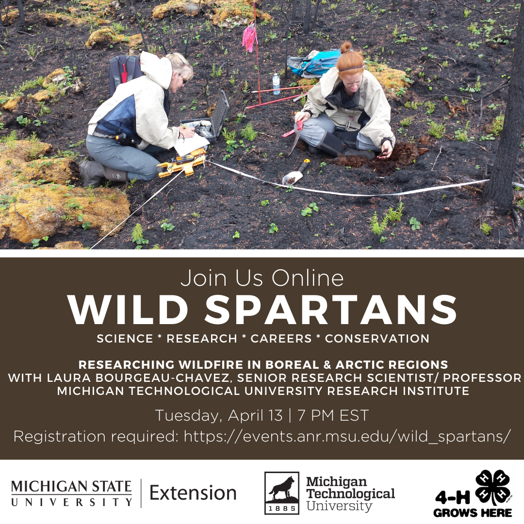
(music “Enthusiasm” by Jay Man is licensed under CC BY 2.0) ( crickets chirping) Thank you all for coming tonight. We have a few more people hopping on. So I'll just get started with a couple of announcements and introductions. So hello everybody and thanks for joining us this evening for our Wild Spartans monthly wildlife science series. This program is created by Michigan 4-H Michigan State University Extension and MSU Department of Fisheries and Wildlife and the Michigan Department of Natural Resources. We have a 136 families registered from across Michigan and from several states. Six others, six or seven in Canada as well. So we are glad to see you all here. I'd like to briefly introduce our other moderators. So we've got Veronica Bulhuis from Kalamazoo county. Anne Kretschmann from Houghton and Keweenaw counties up in the UP. My name is Alexa Warwick and I am a faculty member within the MSU Department of Fisheries and Wildlife. And I will be very glad to be introducing our speaker tonight in just a sec. So just to give you a little bit more info, in this series, we're exploring careers and wildlife conservation, science research, and we'll meet scientists involved in field work. Follow along as they climb through bogs, peer into bear dens, mist net songbirds, snorkel for fish or perhaps even tag deer. We'll meet researchers, learn about their field work and the education and career path they followed to get there. Our program will last with presentations about 30 minutes and we'll have lots of time for questions throughout. So all participants will be muted and the cameras are off. You'll just type in the chat or use that Q&A box at the bottom. And our 4-H staff will see that and, and respond to that and share that with our speaker. So sessions are recorded, but only the presenter and the moderators will appear in the video recording. And if you happen to miss this week, well, we're happy to have you look at the recording later. After the program, we'd invite you to visit our web page and access other resources and activities. And again, recordings of these programs will be posted as they're available. With that, I am again, very glad to introduce our speaker. Laura Bourgeau-Chavez. She's a Senior Research Scientist, Assistant professor at Michigan Technological University and the Michigan Tech Research Institute. She uses drones and radar technology to map and study wild fire effects in boreal and arctic regions. Laura has been a research scientist for 33 years studying forest and wetlands in the field and from space. Linking what she sees in the field to what the satellite sense is the main thrust of her research. My main research focus areas are on wetlands and wildlife. And with that, I am very happy to turn it over to Dr. Bourgeau-Chavez. Thank you for joining us. And thank you for that nice introduction. So as, as she said, I'm a research scientist. I study ecology and remote sensing, mostly satellite remote sensing. And I work for Michigan Tech Research Institute, which is in Ann Arbor, Michigan. So a little bit about my job. I like she said, I I basically use the remote sensing to study what I'm measuring on the ground. Or as far as trees and shrubs and wetlands. Linking what I see there with what the satellite's seeing and being able to map different things across the landscape. So it allows you to take, but you're seeing in one little plot and then apply, apply an algorithm to the remote sensing data to, to map the whole area. Some of the interesting places I study include the boreal forests in Alaska and Canada. And that's what I'm gonna talk about today. Those are my so my favorite projects that I do work on is there, and I'll tell you why boreal forests are special. I also do work in the Great Lakes, Florida, tropics, and a mountain peat-lands. I'll start, oh, I also wanted to say, who funds my research because that's kind of important. So most of it with it being satellites, NASA supports a lot of it because NASA has the satellite's up. But it also gets funded by the Fish and Wildlife, the National Park Service, and the EPA as well as others. So just wanted to start with one of my first projects. I was using satellite radar images from a satellite called ERS. That is, a European Space Agency actually put this one up. And its radar. So it looks a little bit different and it's just black and white images that come out. But if you look, um, I don't know if you can see my cursor, but, up, yeah. Okay. So this blob, this whitish blob, is an area that burned and you can see there's different dates looking at the same place. And you can see it's changing. And radar is really sensitive to moisture. And so what's changing is the moisture. And so even though it already burned in this original project that I did, were able to use that area that burned and how it looked in the imagery to relate that to fire danger. I'm like what, if any of you have seen Smokey the Bear signs in some of the parks are other areas. It'll say what the fire danger is. This really related to that. And just to show that that's me in the field there in this bottom right image. And that's a little bit older, like the fire occurred and 1990. So this is five years later. So vegetation's growing back, so it's not as good as before the vegetation was growing back as far as seeing that soil moisture because the vegetation covering it up. And then outside of the fire, you can see what the forests would look like with the unburned forest. So what led me to studying boreal forests and wildfire. So growing up, I really loved nature and in particular forests and plants in general. And I spent a lot of time climbing trees, hanging out in the woods with my friends, building forts and climbing trees there. We had a pond near our house where we would ice skate. And one of my favorite things to do was to skate in the trees because it was a swamp next to the pond and there was water that froze between the trees. So. We'll play hide and go seek there. Those are probably are some of my favorite things to do as well. It's helping my dad in the yard. So when I was in high school, I was very interested in science as well. And so I just took all the classes I possibly could. I ended up going to the University of Michigan, studied forest ecology, but I really wasn't sure what I would do with my degree when I graduated, I was hired at a place called ERIM, which did for Environmental Research Institute in Michigan. And I was hired because of my degree in forest ecology. But the first thing I did was work with a radar image. And so I learned remote sensing there and they sent me to get a master's degree. And so I got that as well from the University of Michigan, both from the School of Natural Resources and Environment. Then I had a family, I have three children. And 20 years later, I got a doctorate degree from the University of New Brunswick, also in forestry and remote sensing. And my husband wanted me to put this picture on here because he said, one of the best things about getting your PhD is that you get to wear one of these funny hats. I'm not really sure why why you wear such a silly hat when you graduate. But anyway, he thought that was funny. So what, what's so special about these boreal forests in the boreal region. And you can see Michigan is down. You can see that the shape of the mitten there, it's actually part of the Boreal. The upper part of the Upper Peninsula and Canada is the southernmost part of the boreal forest. And it's kind of segregated into mixed wood. The general boreal forest is the green and then the blue is the taiga. It's kind of a transition to the tundra. And these regions are generally have short summers, they're cold, they have permanently frozen ground and under a lot of the areas. And they have a lot of fires that occur there as well. And so these are all the fires by decade. So every 1980 to 1989, for example, are all the green ones. And then the 90s, the 2000s and 2010, all the way up to 2018, this map is showing and these big red fire, that's actually what we'll talk about mostly today. Those are fires that I've been studying for the last five years and the effects of them in Northwest territories. So the black spruce is one of the main trees that grow there. And this is the extent of black spruce from the USGS, where its extent of where it lives, all the way down into Michigan. And this species is really, really kind of special. It's adapted to fire. So it kind of thrives on fire. And these are some blacks spruce. Actually kinda scrawny trees. So you can see this is pretty far north, actually near the tundra zone, the fire, the trees are sparse and really This look like sticks, really. A few little branches on them, especially this one down here. And they have these cones that are adapted to fire, so they stay sealed with the seeds inside until a fire occurs. And then they open after the fire. And they seed. they land on the what, what has been burned, the soil that's been burned, which turns out to be a good seed bed for them. So these fires typically burn the entire canopy. So they're not usually just to ground fire. But the blacks spruce hold on to all there branches and the fires just carried like a ladder and right up the tree. And so this is a comparison of two sites that were near each other, one that was unburned and one that burned. So that's typically what one would look like after fire. This one is actually a peat-lands that has black spruce. And you can see the sphagnum moss there that was killed but not burned. Burns are really variable. So now we have a similar site up and the left, the bottom we have one that it's greening up really fast. The bottom right, it's not and it's got a lot of ash and expose mineral soil. And then this one up in the top right, you can see that trees have actually fallen over. It burns so it's severely. So there's a cycle, the fire here, that lightening is usually the cause of the fire, then it burns the canopy. So you have the burned forest and then you have what's regrowing. Then you get young forest and actually tracks a lot of wildlife. And then it becomes mature. And this takes about a 150 years generally. This about the average of a fire cycle. But because of climate change, it's getting really warmer there, especially in, as for further you go north, the temperatures are increasing more than they are where we are in the temperate zone and is getting drier and wildfire is becoming more frequent. And in Northwest territories where I've been doing this study, they had more fires than any place In the history of Canada. They had 3.4 million hectares burned in just one year. That's 2.5% of the entire territory. It's equal to 8.4 million acres. So my questions were, what burned? By how much, how did it vary, what's regrowing, and how did it affect the wetlands? Because even wetlands were burning. Even though they're wet. They have black spruce and so they were also burning. And so I've been studying these fires, going into the field for the last five years and also collecting imagery over them to study them from space. So Northwest Territories is up up here and they have a really cool license plate, the bear out and there's lots of bears up there. This is me in the middle with the crew doing fieldwork. One of the years, they have a lot of buffalo. It's only, it's mostly wilderness. It's a population of 41,000 people approximately. For comparison, Detroit has 675,000. And you can see this territory is way bigger than even the state of Michigan. That that burned over a 140, 140 fires. And we're only able to get to about well, we didn't get to all the fires, but we got to a bunch of sites to study. So when we go out, we usually have a float plane trip where to a lake that we can access these fires that don't have any roads going to them. And then we do a road trip. And the one near the road trip was an RV which made it easy. Just drive up to your site, could go out there when you wanted to eat lunch. The other trip, we had to take a float plane. And this is looking at the burn from above. And once we got there, we stayed in this lodge. That was the only thing on the entire lake. And we traveled with this ATV and by boats to get to our sites. The first year we got there, we're more fires burning, so it was really, really smoky. But eventually, I think about the fifth or sixth day it rained and it knocked down that smoke. So it's kind of hard to breathe. When we're out there. We have really difficult terrain that we have to get over. There's a lot of fallen branches and you have to climb over them all. Over rocks and there was picky vegetation here that we're trying to get through. Then we have rocks that we have to climb over. This is actually the Precambrian, Precambrian bedrock from the Canadian Shield. And once you get over it, we can see there's actually a peatlands down here that we sampled, which was actually one of my favorite sites. It was hard to get to, but it was actually fun. And at each of these, we actually sample a 152 sites. We set up these plots that are a 100 meters on the side. So we look for an area that is the same kind of pre burned vegetation so the site is similar without and then we subsample it because there's no way we could sample that whole area. So we do 10 by 10 meter plots along two transects until we can get the variable, capture the variability within that site. And we need them this big because the satellite is so far away that we need to be able to have a big area on the ground that we're looking at to relate to the satellite. We collect a lot of things in those ten by ten meter boxes to understand what's going on. So we look at how severely the vegetation and the ground layers burned. Because the ground layers are typically moss and and un-decomposed moss in other branches and other plant parts. That they call peat or duff. We also looked at what was there previously. So we measure all the standing dead trees, get their species and how tall they are. And then we look at what's regrowing, seedlings as well as things sprouting. And then we look at how wet or dry the sites are because that affects, the soil moisture affects, how well it's going to regrow. And what she's holding here is a probe to do that. And then we just characterize the site based on some other variables that will be important for the satellite. So just as an example, for a burn severity, we do, we do this by looking so how much of the trees burned? And so here you can see these in the left. There's just trunks left that were burned and the trees fell over, the middle one, there really aren't any branches left there, just the trunks and they're all if the heat of the fire made them curl because these are really kind of small trees. And then the one on the right, you can see dead needles. So that's a light burn. And the similar for the ground, we do something similar to different severities just based on looking at it. And we quantify that. And then what's regrowing? We look in these small subplots within our 10 by 10, just in the corner of them. And sometimes there's not much. Sometimes there's a lot of stuff. Well, we keep count of everything and if we're lucky we get some black spruce seedlings that we get to see. So this is just some close ups to see what it's like. Hmm, so I think I'm three different sites. Yet. One that the trees were fallen over and then one that had a lot of moss left. And when you start looking closer, you can see everything that's regrowing. And I think I have these sprouts. These are Labrador tea and usually this, you can see the dead shrub branches here. That have survived and so they sprout. And then here's a little black spruce seedling. So we're hoping that the Black Spruce are actually recovering after the fire because they're burning so severely. But we're finding that actually in the upland areas, a lot of times the black spruce doesn't come back and sometimes no trees are coming back, which is not good. But in the peatlands, almost always the black spruce come back. So this is just another look at soil moisture probing that this is what the instrument looks like. You just put it in the ground and, and push a button and then write down what it says. And this is just measuring trees. This we have the little calipers that make it really fast because you can get a lot of trees in a site. Now we are able to count how many are there so we can get densities and what the species are. And then we cut down trees, they're already dead. So we're not hurting them and we cut them and cut what we call a tree cookies that we can count the rings and know how old they are. And that gives us an idea of how long before the previous fire, because they regenerate after fire. And so we can age the stand at the same time. Knowing when the last fire was, And then we look at the soils. And this is the comparison of unburned versus a burn soil profile. And the black is the organic layers. So this is the moss on top of this one. And then dead moss and then the organic layers. And then when you get to the mineral soil, it's more of a brown color. So we take lots of measurements and those, in fact, we harvest what we call brownies because they look like when we're done, little brownies there, five centimeters by 10 by 1 little that we since we know the volume of them, we can weigh them, dry them in a drying oven and weigh them. And then we can get an idea of their bulk density, which is the grams per centimeter cubed of the the volume. To assess digging. And we collect them, keep track of what depth they are as well. So we actually plot the depth versus that bulk density. And this is for some of the fens we looked at, which are a type of peat-land. And the live moss like I showed you is really the lowest bulk density and then those deep layers are the highest. So we need this for some of the modeling that we're doing. And then the soil moisture probes that we used meant for mineral soil. And since these are organic soils, we have to calibrate them. And so we have to harvest all these samples. And we'd set 75 of these buckets from different sites back to Michigan to calibrate those probes in a lab. So this is the total number of sites where I told you we had a 152. Which 85 of those were burned, the rest were unburned. So we kept something to compare it to. And they vary from wetlands. at the top, too lowland that maybe aren't considered necessarily a wetland but they are still kind of wet. And then upland, deciduous, which would be like a Birch or an Aspen. And then Conifer would be the black spruce. And in some cases we have some jack pine. One of the things at these sites we get to see a lot of wildlife, which is fun when we see these buffalo walking down the street. As well as we said, saw quite a few bald eagles. The moose, This is the baby moose. And then we had all these flies that attacked the RV, which was that fun. But we've also seen a lot of bear, which Actually kinda scary because they were grunting at us and some of our sites and we just leave when we see a bear. Don't want to bother them. Then the other things that was it surprises in our site. Where are these earth hummocks. And they are, you can see these, these bumps on the landscape and it's actually ice pushing up. And they were covered with that moss. But when the fire expose these, so these probably existed before the fire. But we're able to see them because of the fire, which is kinda cool. So while we are in the field, all kinds of satellite imagery was being collected. And this is from the Canadian satellite, radar satellite, that are shown here. And all these dots represent those 10 , those 100 by 100 meter plots that we had all over the place. And these are the ones from the flood plain up here. So this is what one looks like up close. And you can see that our field locations along the roads mainly here, and the area that burned, it's the boundaries in red here. This is one from 2014, which initially we were studying and it looks like who ever mapped this fire actually missed part of it. because inside the fire it's very red, outside, blue shade. And then this other one is a 2014 fire. So this, hopefully this works, So this is using that radar data to map drainage patterns and that's important for our understanding what's regrowing across the landscape. So I'm going to flip a little bit so you can see the out put product we made. And maybe you can see the actual shape of the fire scar and the imagery in the background. But we use all those dates of the imagery to create this. And so areas that are really bright all the time are what are generally wetter and areas that are always dark, are generally drier and then in-between they're moderate. And so using that change in them through time, we were able to make this map and then validate it with lots of different datasets. So this is working. So, we're mapping a bunch of fires for drainage in order to to use in our modeling. Did anybody have any questions? We do have a couple. Do the boreal forests stretch to southeast Alaska, like Juneau? What was that? Does it stretch to..? To southeast Alaska like up to Juneau. Might think in Juneau, it, it's not considered boreal. I can go back to that slide at the end if you want. But yeah, there's actually tundra comes down on the side of Alaska. It's not just North, some of its to the west of the Boreal as well. Okay. And have you ever gone out to a fire as its burning or to expand on that a little bit. How soon after a fire have you gone out to do your research? So those fires that I showed that were burning when we were out, we didn't get very close to them because it can be dangerous. And we actually had planned to go to some of those locations, didn't know, not knowing they were burning before we left Michigan. And so we had to kinda change our plans that the soonest after a fire I've been out is two weeks and one of the sites I went out two weeks later was, the vegetation was re-sprouting already. Vegetation can be really resilient. It depends on a lot of factors which is part of what we're trying to understand. What what kind of safety equipment you take with you? especially if you know that there might be smoke and fire smoke. Do you take oxygen with you or other safety equipment? No. and that, When when that was kind of bad because that was when it was really smoky. It's kinda hard to breathe. But we didn't have anything. We weren't expecting that. But we do bring a lot of safety equipment for a couple of reasons because we're so far away. A lot of times, we're, away from any civilization out in the wilderness. So we bring lots of we have a spot unit which we can push the button and it will send a message letting authorities know that we need help, that it's an emergency. We also have a satellite phone, which uses the satellites so because there's no cell service out there. And so that uses the satellites. And then we carry on we carry bear mace. So it shoots 15 feet. Thank goodness. I've never had to use it, but if you do encounter a bear. And you want to try to stay, keep the bear calm and then if they do start to charge you, you have to spray them with the bear mace. And it's been shown it does. It's pretty effective. And then we bring first aid kits. And we actually, NASA provided as a whole bag full of stuff for if our car breaks down. And if someone's in shock, we have a special blankets, like space blankets, similar kinds of stuff. So just because we're in the wilderness and we all have to take wilderness safety classes, including CPR before we can go out there. And when we use the boats, we had to take boat safety. And because we were on a float plane, we had to take airplane safety. So they're very thorough about the safety. We saw the picture of you with two other coworkers. How many people are typically on a team that go out ? So that year there were three of us. I have had only two. But especially after seeing bears, bears usually leave you alone in a group of three or four. And so I always make sure now that we have at least three or four people. And it helps get the work done faster too. All right, and that's it for now. Okay. So now I'm getting to some of the results. So looking at those 142 fires, both from both years, we are assessing what's burning by how much and we're looking in the different zones like it does it matter if it has permafrost or not? Does it matter what season it's burning like spring versus mid summer or fall because you expect it to get a little bit drier. Springs usually wet. you expect things to get drier in the fall. And what what of the vegetation types, which ones are being more resilient to fire? Meaning which ones have the black spruce returning after the fire? Because almost all of them have black spruce in then. Except the open fen, that doesn't have trees. So asking all these questions. So we made, first thing we did was made a map of what the vegetation was. So we can see we have a lot of lot of pink. There's a lot of open open fen , which is a peat-land. A lot of treed fens, and some bogs. And then the, the greens are more of the upland types, so not peatlands. And then the next thing we did was map the severity of the fire. So we use that information that we sampled in the field with the satellite. And the satellite is called Landsat. To make an algorithm that will predict across the whole burn what the burn severity was. And so red here is very severe and one down here that's really severe. Green is not really burned. So there's a lot of areas inside of the perimeters of these fires that didn't burn at all. And so we're trying to understand what causes that as well. And then the third thing we used satellite called Modus, which measures hot spots. So it sees those flaming fronts of the fire. And from that, because it collects every day, you can make maps like these are showing of when it burned. And so the green are June and the orange are mid summer, July, and August. And then the redder ones are September. So now we know the season. We know what it was before it burned, and we know how severely it burns. So we can use those together to try and understand what's going on. And they know what time do we have time for this? I have this. I think they're going to put this in the link to you, but this is kind of showing we have the plain and the shield across this is that lake in the middle and all the fires from 2014 and 2015 fires. And so this is just kinda, kinda have a zoom in of some areas, which is why I wanted to show it. So if you look, the pink areas did not burn as much. They're green here. They're either unchanged or singed. Those are the open fens. They're probably the wettest. So that makes sense. This is on the shield where there's a lot of exposed bedrock. And so it's a little bit drier there. Over here the plain has a lot of those peatland areas. But the question is what makes that fire stop at those edges? So being able to map not only after the fire, what the soil moisture is and the drainage, but having those drainage maps is really important. So we can see if that is one of the variables. So this is on the poster too in that is linked. And then this bottom plot here shows all the areas that we mapped, all the, all 142 fires put into one plot that shows the different types of vegetation. And then from unburned at the bottom, too severe burn at the top. The distribution of those. So open fens are kind of fat at the bottom there, a lot of them unburned. Mid, moderate burn is right in the middle. And so that's about the average for the treed fen, the bog and the deciduous, and then the upland conifer, which is black spruce. oops,wrong slide, Black Spruce and Jack pine mostly are burning the most which, which that makes sense. But we're looking, diving in a little bit deeper. And those are our next steps. These are just a bunch of waterfalls that I was going to show you that a lot of fun things that we get to see when we're in the field. There are any more questions I can go back to the map. Yeah, we have a couple of more questions. How many wildfire I'm sorry, how many wild animals are estimated die in forest fires? Oh, I don't know how many animals I don't know if anyone knows that. We don't usually see remains of them. I think a lot of them are able to get away. Especially in the wilderness like that, unless the fires is really moving quickly. We have seen like antlers that were shed. But that was not an animal that was killed, was just shedding their antlers. And because they really, I think they like the fire afterwards because you get a lot of berries growing. And reindeer lichen, so you get the reindeer, they're eating that as well. That's one of the things that we were measuring in the field. For some people that we're studying reindeer. ok, And then this family would like to know if you ever find a wildfire morels in Michigan. yeah, I should have put those in there. The first year after the fire, there were people who were everywhere collecting them. And we found some and we brought them back to the lodge. And the The owners, the woman cooks and she made a sauce out of them. It was delicious. But yeah, there's a big business. People. I think they made a lot of money doing that. What's one of your most exciting days on the job? That's a good question. That's a hard one. I think I think just going in the field is exciting. Anytime I'm going in the field. It's just because it says usually there's surprises out there like the permafrost heaves that we saw. It just usually some fun stuff. And how much time do you typically spend in the field versus an office analyzing data? So we usually were out for two to three weeks when we go up there. And so it's taken us five years to collect all that data. Just going, but we've had 2 teams sometimes. But it's expensive to go there though, so that that trip is usually two to three weeks. And then I have other fieldwork around Michigan. But I would say a majority of my time is unfortunately spent behind the computer now. Actually in the wintertime. What kind of field work do you do here in Michigan? So I just did some the other day, we're and I don't know if people watched the vernal pool presentation last month, but we're working on a protocol for classifying vernal pools and we're going to be going into the National Parks. So we're going to Sleeping Bear and Pictured Rocks. And then the other team is going to go to Apostle Islands and Voyager this summer. So we get to go out, we mapped where they were, but and we have to go out and verify that that was correct. Oh, this family would like to know how you ended up with this dream job? Could you share the steps? Now, I think it was luck. No. I mean, I does actually finding a job. I just sent letters out to people who said that they I think they had graduated from the School of Natural Resources and they said they would be interested in talking to graduates about potential employment. And so I started sending letters out and they and one of them called me. And they just wanted someone with the forestry degree because they wanted to start. They were studying oceans with remote sensing. And they really wanted to switch to forestry. And so they hired me for my forest background. So if a youth was thinking about getting into this field, what are some steps that they can take now to prepare themselves to go into forestry? So if you want if you want to do the computer work as well, now it's getting more so that you need it helps us further remote sensing. That helps if you have some computer programming skills. So that's one skill that you could work on now. But as far as having most of the classes you would need would just be in college. So I'm not sure. Do do you guys know if there are programs for training for young kids with 4 H for forestry? We have some forestry programs that we do, limited. And so there are volunteer things right? There's some volunteer things you could do. Yes And that was one of the questions that the one of the families had is Are there any internship opportunities or job opportunities for teens within what you do? So we used to have a program here that was for high schoolers. And we have a new lab director and he didn't continue that unfortunately. But we do hire in the summers as young as we might have had like a high school graduate or freshman in college. We hire them for the summer. They do other work here too, besides forests. So they, they do lot of work on the lakes and with those harmful algal blooms and water water quality. And then there's some people doing ice studies up in Alaska. And they actually did polar bear, polar bear dens. They were trying to identify those with radar. If they do some other cool stuff here. Alright. And we have one family who would like to know, is it scary going places where there's not any help? So when I first went to Alaska, I was I was unsure about it because there had been 3, 3 bear attacks before I got there. So that was a little scary. But then I, we just we took the bear safety training and carry the bear mace with us. But other than that, I mean, it's not really usually where we have some people. It's just when you're out and about during the day. You could get lost. Always bring your compass. That's one thing. We're learning. We're learning to read a compass as a good a good skill to have? Yep, That would be a very good skill. Okay. And learning to navigate with it. So when I go into it, I have a really bad sense of direction. So when I go into a site, I always look at my compass first and know which way I went in or out. So I can come back out the same way because it starts to look like once you once you get into a forest, I was just going to ask you, Have you ever gotten lost and needed to have someone come rescue you? No, fortunately, no. But I have had my other colleagues laugh at me for walking the wrong way when I wasn't using my compass. (laughing) How expensive is all the equipment that you use to do your your job? So a lot of it's not really, I mean, we use tapes and there's simple tools for digging, trowels and probably the most expensive thing, are the soil moisture probes. I think those are about I think around $800 for one of those hand-held units. Some of the sites we've put out loggers with probes that we leave out there. And those are a little bit more expensive. Those are maybe $2000 for one unit. We know from seeing the commercials, we know how to, to prevent forest fires for things that youth could do now are things that could be planted that would help prevent forest fires? So most of the problem. They can probably hear about a lot of fire out west. And the problem there is that they suppressed fire for so long. And that all of the underneath, like there's different layers to a forest typically. And out west they normally would have ground fires that would burn the shrubs and the ground vegetation, keeping that so that the fire wouldn't get as hot. And then when it went they wouldn't have these big fires that went into the canopy out west. And so I don't know that planting. You could play into after a fire to prevent erosion. But I think mostly they have been doing thinning of the understory to keep the fires from going into the canopy. And I know that in some of your pictures, you were mentioning different plants and that kind of stuff. So would learn, for youth, would it be a good idea to start identifying plants now, and have that as a skill? That would be a good idea. And you can identify them from different plant parts too. So not just the whole tree, but in the fall you can look at the buds in the buds better than leaves for next year inside the buds. Those are pretty distinct for how they're arranged and what they look like. Is there anyone looking at the effects of the fires on fish or the other animals that depend on the water? Turtles and that kind of stuff? And I don't know. That would be a good thing though. And I know I just I just read a proposal because I sat on a NASA panel review for proposals for grants. There's someone wanted to study the effects on the water quality out west for the whole state of California. So they wanted to look at how the fire is affecting the lake water quality and the and the wildlife that I haven't heard of anybody doing that up in the boreal region though. That might be interesting. Okay, so what are some of the fun things you do when you're out in the wilderness, when you're not working? So we go to they have salmon bakes. Which are kind of cool in in Alaska that they they knew us as they gave us the local discount because we went there's so much. But I mean, we go hike, climb, climb some of the mountains is always fun to see. Seeing some of the different waterfalls like they show in that picture. We would go out there. And when we were at the, it's actually a fishing lodge where we stayed when we took the float plane. And I don't fish, but we had lots of really good fish for dinner. But we would take the boats out with other people who would fish or just take them out for a ride. Go see some there were some waterfalls there in a couple of spots. Have you been able to go out and do any whale watching or anything while you were in Alaska? I have. In Alaska, yeah. Yeah. Actually, So we did we went and saw glaciers there. That was a lot of fun and I've been, I slept on the Arctic Circle. There's a campground there. But that's probably just because usually we're trying to maximize our time when we're out there though and we'll work really long days. We'll work 10 or 12 hour days and then sometimes we're just so exhausted, we just fall asleep. What's probably the most challenging thing about your job? Most challenging. One of the, one of the things is trying to coordinate things, I think is a big challenge, especially if you're trying to, So for this study in particular, NASA was supposed to fly an aircraft with some sensors on it. And so we planned our trip around it. And then when we got there, they got delayed. They were stuck in Montana and couldn't get up there. And they ended up then I think the the plane caught on fire. And so they we ended up the whole trip was planned around this, and then they didn't collect anything until two weeks after we left. And there was nothing we could do. We can't we only we have a budget. So that's one of the challenges, is just coordinating everything. And then some of the, some of the processing of the images can be challenging, trying to, to get rid of things like there's antenna patterns in the images. Sometimes they have to get rid of or terrain correcting it. So when you have rough terrain, the images might look a little funny and you have to correct them. So this family would like to know how much water is needed to put out a forest fire. And obviously we know that there aren't fire hydrants there. So what is the best way to get water to those locations? So they don't really fight these fires unless they're threatening threatening some property. And so that very first one I showed, actually, you can go there. This whoops. Did I show it? This one. There's a town here, you can see the road. And then there's another. So there's a little town here. And the fire, they were trying to protect it. So they do is they cut. They make fire breaks in the ground where they'll clear the vegetation. But the fire was so hot they couldn't do it fast enough. And so they were actually evacuating this whole town. But then the wind shifted. So they got lucky. The wind shifted the other way and the town didn't burn. But the lodge that we stayed at, the fire burned really close to it. And the firefighters, there used the water from the lake. But they also, So they put water on the structures. But they also cut this big fire break which stopped the fire from burning down the lodge. I was there actually, that was pretty cool when I so when I was there and all those fires were burning in 2015, They helicoptered it in all kinds of firefighters there. They were camping behind the lodge. And we had to alter when we ate breakfast because the lodge owner had to feed them all. But they were there to protect the lodge again because they only protect property really. They don't they just otherwise let them burn because it's natural succession that happens up there. And this person would like to know to the bugs in Alaska, carry you away? Oh my gosh, the bugs are huge! But what we've found is that the later in the season you go the less bugs. And so especially mosquitoes. We've been going more. And it just happens that's when NASA has been wanting to fly their centers as well. we've been going in August and they aren't even close to as bad, although I did get bit by a horse fly that got stuck in my shirt sleeve and they take chunks out of you. So you're like bleeding. The person I was with asked me why I was bleeding. And I pull my shirt sleeve up in this giant horse fly flew out. But the dragonflies there are huge as well. And one of them came and ate a horse fly right off of my hat. Just took it right off I like to do things to attract dragonflies. How many trips of you made to Alaska? Oh my gosh. I don't know. So let's see. All right. So I've I actually have so I have some sites there right now on the on the North Slope. But there was a gap where I didn't have any sites there for probably five years, but I probably been there. No. Maybe 15 different years? And the funny thing is the one year I went there, because the satellite was flying over, and I needed soil moisture. I needed soil moisture when it was dry because all i had was soil moisture when it was wet. And so I flew there and drove down to my site. I met someone from a friend from USGS and she went with me and we were out sampling in the middle of nowhere but I didn't know, but they had put a cell tower up because it was near a little town called Delta Junction. And so I don't know why had my cell phone on me but it started ringing in the middle of the forest. I answered and it was my mom. And she asked me where I was and I said Alaska and she said "when you go there?" I said "yesterday," she said "when are you coming back?" I said "tomorrow". Hey, it's a long ways to go. It's like an eight or ten hour flight. But I got the data I needed and it was it was nice and dry and so it helped with my analysis. Nice! And one of our one of our participants used to live in Alaska. So she said the no-see-ems are the worst. I haven't experienced those. I guess I was lucky. Perfect! That's all the questions we have for right now. If anyone has any more, put them in the Q&A. We'll get to them. Otherwise, Alexa is going to talk to you. Thanks so much, Laura, that was really interesting and yeah, there's anything else you want to say at the end here, I'm just at a quick poll to launch and just a couple announcements. So feel free if there's anything else you wanted to mention. I'll just show the waterfalls because I don't think they get to see those maybe. Sounds great. Well, I'll start, I'll start the poll at least to that. As, as people are wrapping up, I know we're getting close to eight o'clock tonight. Just some quick questions there. And if anybody would prefer, we've got a longer version with some other places to put some anonymous feedback as well. And I put that in the chat window. Did you want to put your slide set backed up? Laura or is that...? Or did it.... There it is perfect. Which of these was the like the tallest of the ones. I know it's hard for scale sometimes. And I'm not sure. Thinking about it. Maybe the one, this one here is you're actually looking down on it, but very cool. Well, my favorite of the one on the top, right. Yeah. That one's nice. I think this is actually me standing in front of this one, its hard to see. it's a beautiful sunlight there. Well, I'll let everybody know just to thank everybody and thank you so much, Laura, for speaking tonight and sharing all of these awesome experiences you've had. And again, thanks all of you for joining and for providing questions. And don't forget, there are 4-H clubs in every county across the state. So you can explore wildlife and engage in conservation stewardship activities in your own neck of the woods. Contact your local Michigan State University Extension office to learn more about your 4-H program to get involved. And we'll see everybody next month, May 11th, we'll be hearing from another natural resources professional. Same time, same place. So we look forward to seeing everyone. And thank you once again Laura for joining us tonight. Have a great night, everybody. Thank you. (crickets chirping)


 Print
Print Email
Email