Using road stream crossing surveys to understand creek health
 Print
Print Email
EmailAssessment procedure is a valuable tool for watershed management planning and engaging local volunteers.

Poorly designed road crossings across creeks and streams can lead to damaging erosion and may block fish movement. Road stream crossing surveys are a good source of information about the health of a stream and the conditions of its road crossings. The surveys include a review of the stream above and below the crossing, the crossing itself, and the road as it approaches the stream.
Norton Creek, located in Oakland County, is in the Huron River watershed. The Norton Creek watershed occupies approximately 24.2 square miles, including the cities of Novi, Walled Lake, Wixom, and Wolverine Lake. Based on data collected at several stream locations, the Michigan Department of Environment, Great Lakes, and Energy surmises that the Dissolved Oxygen (DO, also the amount of oxygen available to fish and other wildlife) level in Norton Creek is low because of the high sediment levels and the amount of DO consumed by bacteria in the sediment and algae in the water column, leaving little for the bugs and fish.
The Huron River Watershed Council (HRWC) is developing a Norton Creek Watershed Management Plan. This plan will identify problems in the watershed and recommend solutions. The problem locations will be defined by a series of investigative tools including: biweekly water quality testing at 10 sites, creek walking and paddling on the creek, neighborhood assessments, upland field assessments, and road stream crossing surveys at all of the approximately 53 crossings.
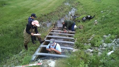
Norton Creek Road Stream Crossing Survey team hard at work.
Road stream crossing surveys will be used to help assess the overall health of the stream and to help locate potential problems. Each survey consists of approximately 65 questions and answers about the crossing, the stream, the road, and erosion. Each survey also has a sketch of the crossing site and photos of the up and downstream crossing, the road approaches, the crossing inlet and the crossing outlet. Once the assessment of the approximately 53 sites is complete, contributions to the stream impairment, especially high erosion crossings, will be evaluated. The sites will be ranked such that follow up can occur at the sites most likely to be contributing to the impairment. Road stream crossing survey results will also be used to evaluate fish access impediments. The road stream crossing data along with the other data sources in the plan will help the HRWC suggest remediation, restoration, and protective actions.
For more information, visit Michigan State University Extension. To have a digest of information delivered straight to your email inbox, visit http://bit.ly/MSUENews.