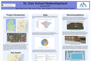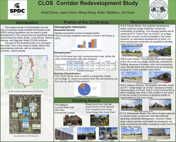
CLOS Corrdior Redevelopment Study Executive Summary and Poster
DOWNLOADMay 24, 2021 - Khalil Davis, Jason Derry, Meng Wang, Aiden Taliaferro, Jim Guan, Michigan State University
 Print
Print Email
Email
The CLOS Corridor Redevelopment Study Report is a product of Michigan State University’s Spring 2021 Semester Urban and Regional Planning Practicum class. The report examines the intersections of Cedar Street, Larch Street, Oakland Avenue, and Saginaw Highway, 0.5 miles northeast of downtown Lansing and provides illustration and explanation regarding the changes that can be expected to occur in Lansing due to newly enacted form-based zoning codes. The reason for the undertaking of this study is to generate a comprehensive analysis of the area’s potential for future growth under form-based zoning codes, as well as the preservation of the existing historical characteristics of the area. The report is designed to be material for presentation to stakeholders within the Lansing community, such as the Michigan Department of Transportation (MDOT), real estate developers, and individual community members.
To gain a better understanding of the demographics, economic characteristics, and current conditions of the CLOS Study Area, data was collected from several sources including the U.S. Census Bureau, ESRI Business Analyst, and local documentation. This data was combined with primary data collected by the practicum team via site visits and stakeholder discussions.
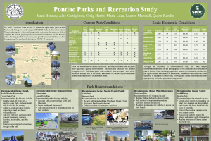
Socio-economic data was used to analyze current demographic and economic characteristics for the block group that the CLOS Study Area is situated mostly within. Analysis revealed that residents in the neighborhood earn lower incomes on average than in other neighborhoods situated around comparable major intersections in the Lansing area. Residents also rent at rates nearly 1.75 times higher than those comparable Lansing-area intersections, while other characteristics like racial makeup, age, and employment are relatively similar to the comparable areas.
Zoning and land use information, provided by the City of Lansing, combined with multiple site visits found that the area’s land use is largely composed of auto-oriented commercial properties with vacant lots and clusters of residential homes scattered throughout. Infrastructure and traffic data, largely sourced from MDOT, reveals that the CLOS intersections have been the site of dozens of pedestrian and bicyclist collisions over the past 10 years and 1,289 auto accidents―over 1,000 more than similar Lansing area intersections. This suggests that serious accommodations need to be made for non-motorized commuters going forward with development.
Retail analysis included industries within the CLOS Study Area that have improved over the last decade. Data shows occupations within entertainment, community and social services, and production work; these sectors would complete the preexisting business complex within the CLOS Study Area. The employment sectors should only be considered as potential suggestions for future developers and stakeholders within the community. Further analysis of the retail data should be considered in a post-covid economy, with applicability to Lansing DT-1 and DT-2 districts.
The Parcel Inventory (Appendix 1) included in this report examines the detailed characteristics and quality of the individual parcels of land within the CLOS Study Area. These characteristics include aspects such as total value of land improvements, total floor area, and ownership as well as others. The information in this parcel inventory is updated to the year of 2021, yet it reports the 2019 zoning class as the new Lansing Form-Based Codes do not go into effect until May 1st, 2021. The data in this section was gathered from the Lansing Parcel Viewer website as well as the BS&A online database supporting the online program.
Recommendations within this report are primarily based on socio-economic data, property data, employment sector data, the practicum team’s assessment of current conditions along the corridor, a community outreach survey performed by the Lansing Corridor Improvement Authority, and the included case study research on noteworthy form-based zoning practices. These recommendations are primarily intended as possible suggestions and imaginations of future developments and should not be received as prescriptions for specific site development or design.
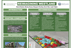
The Lansing Practicum Team isolated four sites within the CLOS Study Area that we believe to be prime for future development. These four locations are all vacant as of 2021, so new infill development at these locations under the 2021 Lansing Form-Based Zoning Codes would likely be easier and more attractive for both the Lansing community and potential developers. These sites would develop under form-based zoning codes, and the four locations will be zoned as either DT-1 Urban Edge and DT-2 Urban Flex districts, which are summarized in this report. Numerous different land uses and structure designs could be built at these vacant locations in Lansing’s future. This report has identified and illustrated a small number of possible designs, yet we believe these to be the most probable based on the data and information analyzed throughout this study.
Street design recommendations included in this report are based on the practicum team’s analyses and case study research where it is apparent that good design and amenities play a critical role in attracting businesses, residents, and clientele to the corridor. Recommendations regarding street amenities include providing increased numbers of street amenities such as benches, bike racks, and signage as some specific examples. In terms of streetscape design, the practicum team has offered visual suggestions of how strategies like road dieting and the redesign of right-of-ways can be utilized to make transit of all kinds more safe, controlled, and enjoyable throughout the CLOS Study Area.
The data and information analyzed throughout this study suggest that there are many opportunities for the CLOS Study Area to redevelop itself as a successful mixed-use Corridor and component of the overall Lansing community. The study area itself has access to a variety of beneficial assets and attractions, and is located down the road from a world-class academic institution at Michigan State University as well as the state capitol of Michigan. Through a strong local planning approach and a unified vision amongst stakeholders, the data and recommendations within this report can assist both the public and private sectors in making decisions that enable appropriate development within the CLOS Study Area.