Northwest Michigan fruit update – May 28, 2019
 Print
Print Email
EmailWe gained growing degree days in warmer conditions over the weekend, but averages are still well behind normal. Tart cherry bloom is underway and apple blossoms are opening.
Weather report
The Memorial Day weekend brought warm and sunny weather, both of which have been hard to come by this season. The daytime high hit above 80 degrees Fahrenheit on Saturday, May 25. Sunday was also warm and the daytime high was 70 F. Rains and cooler weather moved back into the region on Monday, May 27, and this morning we were back down in the 40s with rainy conditions.
We accumulated some growing degree days (GDD) with the recent warm weather, but we are still close to two weeks behind our normal. According to our station calculations, we have accumulated 369 GDD base 42 and 154 GDD base 50. Our 30-plus-year averages are 560.4 GDD base 42 and 276.8 GDD base 50. On Michigan State University Enviroweather, the Northwest Michigan Horticulture Research Center station calculates GDD using the Baskerville-Emin method and using this method, we are at 415 GDD base 42 and 182 GDD base 50.
Friday and Sunday were the only days that did not have rain last week. The Northwest Michigan Horticulture Research Center had 0.35 inch of rain on May 22, 0.08 inch on May 23, 0.54 inch on May 25, 0.65 inch on May 27, and it is still raining this morning. MSU agricultural meteorologist Jeff Andresen predicts that the wet and cool weather will continue for the next few weeks, and that the long-term forecast has changed: the summer is not likely to be warmer and wetter than normal. Visit the Fruit & Nuts weather page to hear his latest forecast.
Crop report
Tart cherry bloom came and went at the Northwest Michigan Horticulture Research Center, and petals are just starting to drop. We did have some good pollination weather over the weekend, and bees were active with the warm conditions. Tart cherry bloom is still underway in the northern part of the region, and hopefully conditions will warm in the coming days. Temperatures are predicted to go up, but overnight temperatures will remain in the 50s.
Sweet cherries are coming out of the shuck, and the overall crop size is unknown as we did not have great pollination conditions.
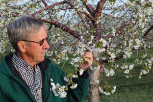
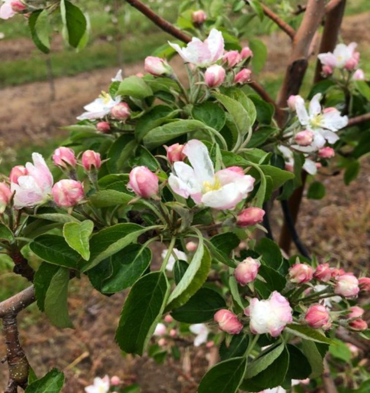
Apple blossoms began opening over the weekend.
Pest report
We have had more days with rainfall recently, and these wet conditions have been concerning for tree fruit diseases. Disease programs, particularly targeting apple scab, fire blight blossom blight and cherry leaf spot continue to be the primary management concern at this time; growers making an application has been a challenge in wet weather. Although the forecast continues to look moderate in terms of temperature, we could start to see an uptick in pest activity (for example, plum curculio) in drier, warmer days, and these conditions should be more favorable for pollinator activity during apple bloom.
We have observed increased tissue growth in the warmer days and rain in the last week. Many growers found opportunities to cover this tissue going into recent wetting periods. We had four wetting periods since our May 22 report, with the most recent that spanned from yesterday evening into this morning, resulting in an apple scab infection. Over the weekend, a rain shower that came in the early morning brought humid conditions that lasted for a good portion of the morning and afternoon of May 25; the Enviroweather model reported 95% progress toward infection, but due to microclimates, some areas could have experienced an infection despite the model not reaching 100% progress toward infection. Following warmer temperatures, the number of scab spores discharged during these rain events has increased significantly according to RIMpro.
Deciding when to begin fire blight programs has been difficult as apple bloom has had a slow start and temperatures have both increased and decreased the growth of the epiphytic infection potential (EIP) values on fire blight models over the weekend. Just a few open blossoms may not warrant fire blight management, but fire blight control may be needed when blocks reach greater than 10% open blossoms, if other parameters—temperature, wet weather, EIPs over 70—are met. Some growers used or considered applying oxytetracycline to inhibit bacterial growth to save bactericides for potentially more extreme fire blight conditions during bloom. The forecast is calling for moderate daytime temperatures in the 60s and 70s, cooler evenings and relatively dry weather. As a result, there appears to be little risk for fire blight infection in the coming week, but continue checking the model regularly as EIPs can change quickly as current conditions and forecasts are updated.
Black stem borer activity is ongoing at the research station with two beetles in our trap this week. We also had our first black stem borer detection on Old Mission Peninsula this week. Trap catches remain low in the single digits at this time. Excessive rainfall could cause stress to trees if soils remain wet, particularly in flooded areas. The traditional material (i.e., chlorpyrifos) used for borers has shown relatively poor efficacy for this pest. Additionally, we do not suggest using insecticides in orchards during bloom to prevent any negative effects on pollinators. We are not yet at peak black stem borer emergence, which is the optimal timing for management.
Spotted tentiform leafminer activity is ongoing with consistent numbers in traps.
In cherries, wet weather has been conducive for cherry leaf spot infections. Tart cherries that have been considering low input/cost management programs should continue management efforts for cherry leaf spot. If this disease gets a foothold early, there is a risk of early defoliation that will have more long-term effects on tree health and winter hardiness. For more information on low input programs, please refer to the MSU Extension article, “Low spray programs for tart cherry.”
Although temperatures are still relatively cool, there are a few warm days in the forecast, and we could see some early plum curculio activity later this week. We have not detected plum curculio yet this season, but stone fruits such as apricots and sweet cherries coming out of the shuck are susceptible to plum curculio oviposition, if this pest is active. Plum curculio activity is typically associated with a few consecutive warm days. According to “Common Tree Fruit Pests” by Angus Howitt (1993), both moisture and temperature are important factors of plum curculio behavior. We have had more than adequate moisture this season and there are a few temperature indicators that can be used to estimate their emergence including: 1) average temperatures between 55 and 60 F for three to four days, 2) average temperatures above 60 F for three days, and 3) maximum temperatures of 75 F for two consecutive days. Due to this season’s cooler spring, it could take a few extra days to trigger plum curculio activity, and we could see relatively low activity overall if the cooler temperatures persist. However, if temperatures warm considerably, we could see a big flush of plum curculio and oviposition.
American plum borer activity has begun with one moth per trap and we found one green fruitworm moth in traps this week. In general, wet weather has slowed moth activity by inhibiting their ability to fly, but we anticipate an uptick in pest activity in drier weather.